Toggle navigation
LMEC Home
Exhibitions
Georeferencing
Tools for Teachers
Collections
My Favorites
Sign Up / Log In
Search
Search the map portal
Map Collection
Map Collection
Map Sets
Search
Search
Search for
Search In
All Fields
Creator
Title
Subject
Place
Search All Digital Collections
Advanced Search
722 Results
My Search
Start Over
Subject
aerial views
Remove constraint Subject: aerial views
Filter your Search
Place
North and Central America
654
United States
624
Massachusetts
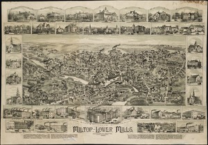
295
Suffolk (county)
65
Boston
63
New Hampshire
55
Connecticut
53
Middlesex (county)
53
more
Place
»
Topic
Boston (Mass.)--Aerial views
42
Franco-Prussian War, 1870-1871--Aerial views
7
Aerial views
6
France--History--1789-1900--Aerial views
6
Germany--History--1789-1900--Aerial views
6
United States--History--Revolution, 1775-1783--Maps
6
Boston (Mass.)--History--Revolution, 1775-1783--Aerial views--Early works to 1800
5
Boston (Mass.)--History--Siege, 1775-1776--Aerial views--Early works to 1800
5
more
Topic
»
Date
Date range begin
–
Date range end
Current results range from
1493
to
2020
View distribution
Creator
O.H. Bailey & Co
146
Norris, George E.
51
Burleigh, L. R., 1853-1923
47
Bailey, O. H. (Oakley Hoopes), 1843-1947
41
Poole, A. F.
22
Bailey, H. H. (Howard Heston), 1836-1878
20
Bachmann, John, fl. 1849-1885
8
Fowler, T. M. (Thaddeus Mortimer), 1842-1922
8
more
Creator
»
Format
Maps/Atlases
699
Prints
18
Manuscripts
12
Drawings/Illustrations
11
Georeferenced
Yes
5
No
717
Collection
Norman B. Leventhal Map & Education Center Collection
694
Urban Maps
575
Boston and New England Maps
449
American Revolutionary War-Era Maps
30
Richard H. Brown Revolutionary War Map Collection at Mount Vernon
11
Boston Redevelopment Authority Collection
8
William L. Clements Library Collection
7
Library of Congress Collection
4
more
Collection
»
Available to use
No known restrictions
691
Creative Commons license
20
Search Constraints
Sort by relevance
relevance
title
date (asc)
date (desc)
Number of results to display per page
20 per page
10
per page
20
per page
50
per page
100
per page
View results as:
grid view
map view
Search Results
21.
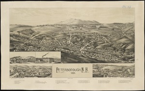
Peterborough, N.H : 1886
22.
View of Whitman and Brockton, showing location of some of the most desirable building lots, for sale by W.V. Everson, 120...
23.
Veduta d'Italia
24.
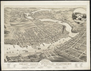
Panoramic view of the city of Calais, St. Stephen and Milltown : Washington Co. Maine, Charlotte Co. New Brunswick : mills,...
25.
Transylvania campaigne Oct. 1916 ; Macedonian campaigne ; Somme Campaigne Oct. 1916
26.
Aerial photo of Charlestown, Massachusetts
27.
Alton and Alton Bay, N.H : 1888
28.
Bird's eye view of Pawtucket & Central Falls, R.I. 1877
29.
Bird's eye view of the village of Campello : in the town of Brockton, Plymouth County, Mass., 1880
30.
Edgartown, Duke's County, Martha's Vineyard Id., Mass
31.
The embankment and park on Charles River Bay
32.
Foxborough, Mass : 1879
33.
Foxborough, Massachusetts : 1888
34.
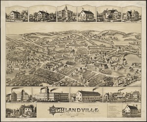
Highlandville, Massachusetts : 1887
35.
Hope, Jackson, Fiskville and Arkwright, Rhode Island
36.
Mattapan, Massachusetts, 1890
37.
Milton, Lower Mills, Massachusetts : 1890
38.
Pigeon Cove, Rockport, Essex County, Mass
39.
Pontiac, Rhode Island
40.
South New Market : Rockingham County, N.H. 1884
‹ Prev
Next ›
1
2
3
4
5
6
…
36
37