Toggle navigation
LMEC Home
Exhibitions
Georeferencing
Tools for Teachers
Collections
My Favorites
Sign Up / Log In
Search
Search the map portal
Map Collection
Map Collection
Map Sets
Search
Search
Search for
Search In
All Fields
Creator
Title
Subject
Place
Search All Digital Collections
Advanced Search
970 Results
My Search
Start Over
More Like
commonwealth-oai:r4950j238
Remove constraint More Like: commonwealth-oai:r4950j238
Filter your Search
Place
North and Central America
944
United States
678
Canada
205
New York
199
Quebec
111
Pennsylvania
90
New Jersey
62
Virginia
49
more
Place
»
Topic
United States--History--Revolution, 1775-1783--Maps
305
United States--History--French and Indian War, 1754-1763--Maps
149
Pennsylvania--Maps
50
Saint Lawrence River--Maps
43
Maryland--Maps
37
New York (State)--Maps
32
Newport (R.I.)--Maps
27
New Jersey--Maps
23
more
Topic
»
Date
Date range begin
–
Date range end
Current results range from
1700
to
1931
View distribution
Creator
Rocque, Mary Ann
29
Bellin, Jacques Nicolas, 1703-1772
26
Holland, Samuel, 1728-1801
25
Montrésor, John, 1736-1799
25
Jefferys, Thomas, -1771
24
Clinton, Henry, Sir, 1738?-1795
19
Robert Sayer and John Bennett (Firm)
15
Hills, John, active 1777-1819
13
more
Creator
»
Format
Maps/Atlases
954
Drawings/Illustrations
11
Documents
5
Manuscripts
1
Prints
1
Georeferenced
Yes
19
No
951
Collection
American Revolutionary War-Era Maps
921
William L. Clements Library Collection
909
Norman B. Leventhal Map & Education Center Collection
52
American Antiquarian Society Collection
7
MacLean Collection Map Library
2
Urban Maps
2
Available to use
No known restrictions
52
Search Constraints
Sort by relevance
relevance
title
date (asc)
date (desc)
Number of results to display per page
20 per page
10
per page
20
per page
50
per page
100
per page
View results as:
grid view
map view
Search Results
1.
A chorographical map of the country round Philadelphia = Carte particuliere des environs de Philadelphia
2.
Delaware Bay and Chesapeake Bay
3.
Delaware Bay and Chesapeake Bay
4.
A map of the Delaware and Chesapeak bays with the peninsula between them
5.
Manuscript maps of U.S. states
6.
Post route map of the states of Pennsylvania, New Jersey, Delaware, and Maryland and of the District of Columbia with adjacent...
7.
A compleat plan of part of the province of Pennsylvania East and West Jersey shewing the transactions of the royal army under...
8.
A draft of the Ohio from an Indian account
9.
A map of the country between Will's Creek & Monongahela River shewing the rout and encampments of the English army, in 1755
10.
Colton's new topographical map of the states of Virginia, Maryland & Delaware, showing also eastern Tennessee & parts of other...
11.
Colton's new topographical map of the states of Virginia, West Virginia, Maryland & Delaware and portions of other adjoining...
12.
Delaware and Maryland
13.
Johnson's Virginia, Delaware, Maryland & West Virginia
14.
Map of the State of Virginia
15.
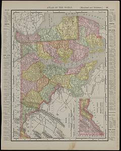
Maryland and Delaware ; Rand McNally & Co.'s map of the main portion of Baltimore
16.
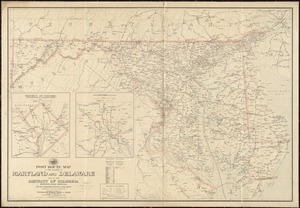
Post route map of the states of Maryland and Delaware and of the District of Columbia showing post offices with the...
17.
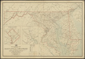
Post route map of the states of Maryland and Delaware and of the District of Columbia showing post offices with the...
18.
Post route map of the states of Virginia and West Virginia together with Maryland and Delaware with adjacent parts of...
19.
Scarborough's new county and post office map of Virginia, Maryland, Delaware, and District of Columbia : with complete index...
20.
The seat of war : birds eye view of Virginia, Maryland, Delaware, and the District of Columbia
‹ Prev
Next ›
1
2
3
4
5
…
48
49