Toggle navigation
LMEC Home
Exhibitions
Georeferencing
Tools for Teachers
Collections
My Favorites
Sign Up / Log In
Search
Search the map portal
Map Collection
Map Collection
Map Sets
Search
Search
Search for
Search In
All Fields
Creator
Title
Subject
Place
Search All Digital Collections
Advanced Search
1232 Results
My Search
Start Over
More Like
commonwealth-oai:bv73gz10n
Remove constraint More Like: commonwealth-oai:bv73gz10n
Filter your Search
Place
North and Central America
1,202
United States
929
Massachusetts
267
New York
253
Canada
212
Quebec
113
Pennsylvania
70
Suffolk (county)
67
more
Place
»
Topic
United States--History--Revolution, 1775-1783--Maps
306
Massachusetts--Maps
235
United States--History--French and Indian War, 1754-1763--Maps
162
New York (State)--Maps
85
Boston (Mass.)--Maps
56
Saint Lawrence River--Maps
43
New England--Maps
38
Rhode Island--Maps
35
more
Topic
»
Date
Date range begin
–
Date range end
Current results range from
1700
to
2020
View distribution
Creator
Rocque, Mary Ann
29
Jefferys, Thomas, -1771
28
Holland, Samuel, 1728-1801
26
Bellin, Jacques Nicolas, 1703-1772
25
Montrésor, John, 1736-1799
25
MassGIS (Office : Mass.)
20
Clinton, Henry, Sir, 1738?-1795
19
Geo. H. Walker & Co
16
more
Creator
»
Format
Maps/Atlases
1,214
Drawings/Illustrations
11
Documents
5
Manuscripts
5
Prints
2
Ephemera
1
Georeferenced
Yes
76
No
1,156
Collection
American Revolutionary War-Era Maps
956
William L. Clements Library Collection
909
Norman B. Leventhal Map & Education Center Collection
270
Boston and New England Maps
191
Maps from AAS
21
Applied Geographics, Inc. Records
20
David Judkins Weaver Papers
18
Urban Maps
11
more
Collection
»
Available to use
No known restrictions
264
Creative Commons license
17
Search Constraints
Sort by relevance
relevance
title
date (asc)
date (desc)
Number of results to display per page
20 per page
10
per page
20
per page
50
per page
100
per page
View results as:
grid view
map view
Search Results
21.
A map of lot no 1 in the Hardenbergh Patent
22.
Part of the counties of Charlotte and Albany, in the province of New York; being the seat of war between the king's forces...
23.
Part of the modern counties of Union, Somerset, Hunterdon, Morris, Essex, Bergen, Passaic, Sussex, and Warren in New Jersey and...
24.
Post road & Kaskutahook
25.
Sketch of different passes into Canada from our lower provinces
26.
Southern New York and northern New Jersey
27.
Subdivision of lot no. 12 in the Good Beer Kill tract : performed this 4th day of Octr. 1797
28.
Survey bill of Peter Hams farm, (as he now has the same in fence) situate in great lot no. 2 in the manor of Livingston :...
29.
White Plains
30.
An accurate map of Canada, with the adjacent countries; exhibiting the late seat of war between the English & French in those...
31.
Attaques des forts de Chouaguen en Amérique pris par les français commandés par le Marquis de Montcalm le 14 Août 1756
32.
Attaques des retranchemens devant le fort Carillon en Amérique par les anglais commandés par le général Abercrombie contre les...
33.
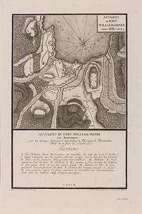
Attaques du fort William-Henri en Amérique par les troupes français aux ordres du Marquis de Montcalm prise de ce fort le 7...
34.
British attack upon Ticonderoga, July 7 & 8, 1758
35.
The Cedres
36.
Continuation of the Grande Riviere with the village of Fariole lying near Cape Torment on the north shore
37.
Continuation of the River Chaudière &c.
38.
Continuation of the River Chaudière from where it falls into the St. Lawrence, as laid down in the lower plan, to the village...
39.
Continuation of the River Chaudière joining to A
40.
Continuation of the River Chaudière joining to B
‹ Prev
Next ›
1
2
3
4
5
6
…
61
62