Toggle navigation
LMEC Home
Exhibitions
Georeferencing
Tools for Teachers
Collections
My Favorites
Sign Up / Log In
Search
Search the map portal
Map Collection
Map Collection
Map Sets
Search
Search
Search for
Search In
All Fields
Creator
Title
Subject
Place
Search All Digital Collections
Advanced Search
973 Results
My Search
Start Over
More Like
commonwealth-oai:b5648r828
Remove constraint More Like: commonwealth-oai:b5648r828
Filter your Search
Place
North and Central America
945
United States
684
New York
229
Canada
206
Quebec
112
Pennsylvania
61
New Jersey
60
Massachusetts
49
more
Place
»
Topic
United States--History--Revolution, 1775-1783--Maps
330
United States--History--French and Indian War, 1754-1763--Maps
149
New York (N.Y.)--Maps
48
Saint Lawrence River--Maps
43
Manhattan (New York, N.Y.)--Maps
30
Newport (R.I.)--Maps
27
New York (State)--Maps
26
Hudson River (N.Y. and N.J.)--Maps
22
more
Topic
»
Date
Date range begin
–
Date range end
Current results range from
1700
to
1932
View distribution
Creator
Rocque, Mary Ann
29
Holland, Samuel, 1728-1801
26
Jefferys, Thomas, -1771
25
Montrésor, John, 1736-1799
25
Bellin, Jacques Nicolas, 1703-1772
24
Clinton, Henry, Sir, 1738?-1795
19
Robert Sayer and John Bennett (Firm)
16
Kitchin, Thomas, 1719-1784
14
more
Creator
»
Format
Maps/Atlases
957
Drawings/Illustrations
11
Manuscripts
6
Documents
5
Prints
1
Georeferenced
Yes
11
No
962
Collection
American Revolutionary War-Era Maps
936
William L. Clements Library Collection
909
Norman B. Leventhal Map & Education Center Collection
38
Urban Maps
25
American Antiquarian Society Collection
11
Boston and New England Maps
5
New-York Historical Society Collection
4
MacLean Collection Map Library
3
more
Collection
»
Available to use
No known restrictions
42
Creative Commons license
5
Search Constraints
Sort by relevance
relevance
title
date (asc)
date (desc)
Number of results to display per page
20 per page
10
per page
20
per page
50
per page
100
per page
View results as:
grid view
map view
Search Results
421.
Carte du Golphe de St. Laurent et pays voisins pour servir à l'histoire générale des voyages
422.
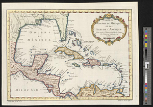
Carte du Golphe du Méxique et des isles de l'Amérique : pour servir à l'Histoire générale des voyages
423.
Carte du gouvernement de Montréal
424.
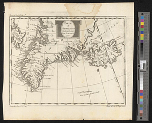
Carte du Groenland dressée et gravée
425.
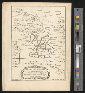
Carte du Lac de Mexico et de ses environs lors de la conqueste des Espagnols : pour servir a l'histoire générale des voyages
426.
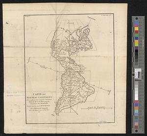
Carte du nouveau continent selon sa plus grande longueur diamètrale depuie la riv'. de la Plata jusqu'au delà du lac des...
427.
Carte d'une partie de l'Amérique Septentrionale tirée des manuscripts de M. Guill. De l'Isle ou l'on voit son systeme en 1695...
428.
Carte geo-hydrographique du Golfe du Mexique et de ces isles : construit d'après les mémoires les plus recens, et assujeties...
429.
Castle Island in Boston Harbor
430.
The Cedres
431.
Channels around the Island of Orleans
432.
Charlestown, Breed's Hill, and Bunker Hill
433.
Charlotte Town the capital of the island of St. John
434.
Chart of the coast of Honduras and Nicaragua
435.
Chart of the east coast of the Yucatan
436.
A chart of the harbour of Rhode Island and Narraganset Bay surveyed in pursuance of directions from the Lords of Trade to his...
437.
A chart of the harbour of Rhode Island and Narraganset Bay surveyed in pursuance of directions from the Lords of Trade to his...
438.
A chart of the peninsula of Nova Scotia
439.
A chart of Tibee Inlet in Georgia
440.
A chart shewing the tract of Capt. Cook's last voyage, 1799
‹ Prev
Next ›
1
2
…
18
19
20
21
22
23
24
25
26
…
48
49