Toggle navigation
LMEC Home
Exhibitions
Georeferencing
Tools for Teachers
Collections
My Favorites
Sign Up / Log In
Search
Search the map portal
Map Collection
Map Collection
Map Sets
Search
Search
Search for
Search In
All Fields
Creator
Title
Subject
Place
Search All Digital Collections
Advanced Search
1021 Results
My Search
Start Over
More Like
commonwealth-oai:9306xx619
Remove constraint More Like: commonwealth-oai:9306xx619
Filter your Search
Place
North and Central America
993
United States
730
New York
254
Canada
208
Quebec
112
New Jersey
81
Pennsylvania
71
Massachusetts
52
more
Place
»
Topic
United States--History--Revolution, 1775-1783--Maps
330
United States--History--French and Indian War, 1754-1763--Maps
150
New York (State)--Maps
85
Saint Lawrence River--Maps
43
New Jersey--Maps
40
Pennsylvania--Maps
29
Newport (R.I.)--Maps
27
Hudson River (N.Y. and N.J.)--Maps
23
more
Topic
»
Date
Date range begin
–
Date range end
Current results range from
1700
to
1976
View distribution
Creator
Rocque, Mary Ann
29
Holland, Samuel, 1728-1801
26
Bellin, Jacques Nicolas, 1703-1772
25
Jefferys, Thomas, -1771
25
Montrésor, John, 1736-1799
25
Clinton, Henry, Sir, 1738?-1795
18
Robert Sayer and John Bennett (Firm)
16
Hills, John, active 1777-1819
13
more
Creator
»
Format
Maps/Atlases
1,005
Manuscripts
12
Drawings/Illustrations
11
Documents
5
Prints
1
Georeferenced
Yes
21
No
1,000
Collection
American Revolutionary War-Era Maps
955
William L. Clements Library Collection
909
Norman B. Leventhal Map & Education Center Collection
70
Boston and New England Maps
18
Maps from AAS
17
New-York Historical Society Collection
9
MacLean Collection Map Library
7
Newberry Library Collection
3
more
Collection
»
Available to use
No known restrictions
79
Creative Commons license
6
Search Constraints
Sort by relevance
relevance
title
date (asc)
date (desc)
Number of results to display per page
20 per page
10
per page
20
per page
50
per page
100
per page
View results as:
grid view
map view
Search Results
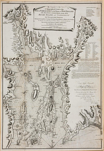
321.
A topographical chart of the bay of Narraganset in the province of New England, with all the isles contained therein, among...
322.
The United States of America laid down from the best authorities, agreeable to the peace of 1783
323.
Valley of the Hudson River from Fishkill to Teller's Point
324.
Verplanks
325.
Verplanks Point
326.
View from the blockhouse : Dorchester Neck
327.
View of Dorchester Neck from Enoch Brown's
328.
View of Dorchester Neck, from the mess house on Fort Hill
329.
View of Dorchester Neck, from the mess house on Fort Hill
330.
A view of the Great Bridge near Norfolk in Virginia where the action happened between a detachment of the 14th Regt: & a body...
331.
Washingtons position at Morristown 1780 : headquarters at Fords house
332.
West Point
333.
West Point and the Hudson River
334.
West Point and vicinity
335.
West Point; or Fort Defiance
336.
Williamsburgh & the slip of land between York & James rivers from thence to Hampton
337.
Yorktown, Virginia, and the surrounding area, ca. 1781
338.
Cross Roads to East Chester, and above : no 19
339.
Lake Champlain streamline ferries : direct routes to Whiteface Mtn., Ausable Chasm, scenic short-cuts between Green Mountains,...
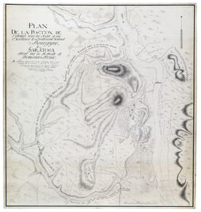
340.
Plan de la position de l'armée sous les ordre de son Excellence le Lieutenant General Bourgoyne à Saratoga etant sur la...
‹ Prev
Next ›
1
2
…
13
14
15
16
17
18
19
20
21
…
51
52