Toggle navigation
LMEC Home
Exhibitions
Georeferencing
Tools for Teachers
Collections
My Favorites
Sign Up / Log In
Search
Search the map portal
Map Collection
Map Collection
Map Sets
Search
Search
Search for
Search In
All Fields
Creator
Title
Subject
Place
Search All Digital Collections
Advanced Search
970 Results
My Search
Start Over
More Like
commonwealth-oai:0z70dt052
Remove constraint More Like: commonwealth-oai:0z70dt052
Filter your Search
Place
North and Central America
940
United States
659
Canada
250
New York
195
Quebec
113
Pennsylvania
60
New Jersey
54
Nova Scotia
49
more
Place
»
Topic
United States--History--Revolution, 1775-1783--Maps
305
United States--History--French and Indian War, 1754-1763--Maps
162
Canada--Maps
55
Saint Lawrence River--Maps
43
United States--Maps
34
New York (State)--Maps
27
Newport (R.I.)--Maps
27
Hudson River (N.Y. and N.J.)--Maps
21
more
Topic
»
Date
Date range begin
–
Date range end
Current results range from
1700
to
1965
View distribution
Creator
Rocque, Mary Ann
29
Jefferys, Thomas, -1771
28
Bellin, Jacques Nicolas, 1703-1772
25
Holland, Samuel, 1728-1801
25
Montrésor, John, 1736-1799
25
Clinton, Henry, Sir, 1738?-1795
19
Robert Sayer and John Bennett (Firm)
16
Orme, Robert, -1781
14
more
Creator
»
Format
Maps/Atlases
954
Drawings/Illustrations
11
Documents
5
Prints
1
Georeferenced
Yes
4
No
966
Collection
American Revolutionary War-Era Maps
934
William L. Clements Library Collection
909
Norman B. Leventhal Map & Education Center Collection
40
American Antiquarian Society Collection
14
Richard H. Brown Revolutionary War Map Collection at Mount Vernon
4
Boston and New England Maps
2
MacLean Collection Map Library
2
Applied Geographics, Inc. Records
1
more
Collection
»
Available to use
No known restrictions
41
Creative Commons license
4
Search Constraints
Sort by relevance
relevance
title
date (asc)
date (desc)
Number of results to display per page
20 per page
10
per page
20
per page
50
per page
100
per page
View results as:
grid view
map view
Search Results
961.
West Indies
962.
West Point
963.
West Point and the Hudson River
964.
West Point and vicinity
965.
West Point; or Fort Defiance
966.
The Western Hemisphere from the latest discoveries
967.
White Plains
968.
Williamsburgh & the slip of land between York & James rivers from thence to Hampton
969.
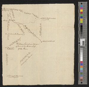
Wm. Croghans 984 acres on Skeggs beaver creek
970.
Yorktown, Virginia, and the surrounding area, ca. 1781
‹ Prev
Next ›
1
2
…
45
46
47
48
49