Toggle navigation
LMEC Home
Exhibitions
Georeferencing
Tools for Teachers
Collections
My Favorites
Sign Up / Log In
Search
Search the map portal
Map Collection
Map Collection
Map Sets
Search
Search
Search for
Search In
All Fields
Creator
Title
Subject
Place
Search All Digital Collections
Advanced Search
1078 Results
My Search
Start Over
More Like
commonwealth:z603vw10q
Remove constraint More Like: commonwealth:z603vw10q
Filter your Search
Place
North and Central America
1,010
United States
940
Suffolk (county)
775
Boston
773
Massachusetts
666
Downtown Boston
35
New York
34
Boston Harbor
30
more
Place
»
Topic
Boston (Mass.)--Maps
752
City planning--Massachusetts--Boston--Maps
104
Real property--Massachusetts--Boston--Maps
99
Landowners--Massachusetts--Boston--Maps
74
Urban renewal--Massachusetts--Boston--Maps
63
Local transit--Massachusetts--Boston--Maps
47
Massachusetts--Maps
46
Land use--Massachusetts--Boston--Maps
35
more
Topic
»
Date
Date range begin
–
Date range end
Current results range from
1634
to
2023
View distribution
Creator
Boston Redevelopment Authority
114
Faden, William, 1749-1836
33
Jefferys, Thomas, -1771
29
Geo. H. Walker & Co
27
Des Barres, Joseph F. W. (Joseph Frederick Wallet), 1722-1824
26
Le Rouge, Georges-Louis
23
Boynton, George W., d. 1884
21
Sampson, Davenport & Co
21
more
Creator
»
Format
Maps/Atlases
1,035
Manuscripts
33
Prints
32
Drawings/Illustrations
9
Books
2
Georeferenced
Yes
111
No
967
Collection
Norman B. Leventhal Map & Education Center Collection
637
Boston and New England Maps
605
Urban Maps
493
American Revolutionary War-Era Maps
343
Richard H. Brown Revolutionary War Map Collection at Mount Vernon
293
Boston Redevelopment Authority Collection
120
Mapping Boston Collection
23
Massachusetts Real Estate Atlases
12
more
Collection
»
Available to use
No known restrictions
705
Creative Commons license
333
Search Constraints
Sort by relevance
relevance
title
date (asc)
date (desc)
Number of results to display per page
20 per page
10
per page
20
per page
50
per page
100
per page
View results as:
grid view
map view
Search Results
501.
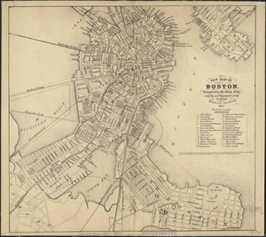
New map of Boston, comprising the whole city, with the new boundaries of the wards
502.
New map of Boston, comprising the whole city, with the new boundaries of the wards
503.
New map of Boston, comprising the whole city, with the new boundaries of the wards
504.
New map of Boston, comprising the whole city, with the new boundaries of the wards
505.
New map of Boston, comprising the whole city, with the new boundaries of the wards
506.
New map of Boston, comprising the whole city, with the new boundaries of the wards
507.
New map of Boston, comprising the whole city, with the new boundaries of the wards
508.
New map of Boston, comprising the whole city with the new boundariess of the wards
509.
New map of Boston from latest surveys
510.
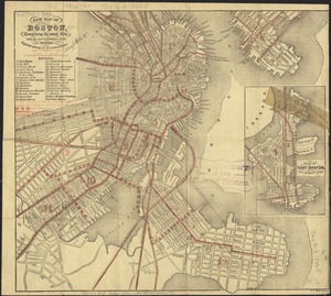
New map of Boston giving all points of interest : with every railway & steamboat terminus, prominent hotels, theatres & public...
511.
New map of Boston giving all points of interest : with every railway & steamboat terminus, prominent hotels, theatres & public...
512.
New map of Boston giving all points of interest : with every railway & steamboat terminus, prominent hotels, theatres & public...
513.
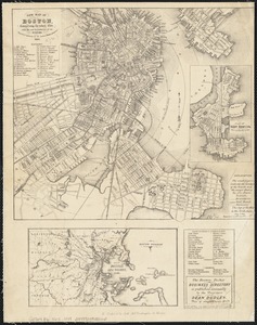
New map of the central portion of Boston
514.
New map of the vicinity of Boston, with the dates of settlement and distance from the capital
515.
New map of the vicinity of Boston, with the dates of settlement and distance from the capital
516.
New map of the vicinity of Boston, with the dates of settlement, population in 1840, and distance from the capital
517.
A new plan of Boston : drawn from the best authorities with the latest improvements, additionas and corrections
518.
A new plan of ye great town of Boston in New England in America with the many additionall buildings & new streets to the year 1743
519.
New public library building, Boston, Mass. : 1/4 inch scale drawing for foundations of columns at Dartmouth Street entrance
520.
North Harvard project area : locality map
‹ Prev
Next ›
1
2
…
22
23
24
25
26
27
28
29
30
…
53
54