Toggle navigation
LMEC Home
Exhibitions
Georeferencing
Tools for Teachers
Collections
My Favorites
Sign Up / Log In
Search
Search the map portal
Map Collection
Map Collection
Map Sets
Search
Search
Search for
Search In
All Fields
Creator
Title
Subject
Place
Search All Digital Collections
Advanced Search
144 Results
My Search
Start Over
More Like
commonwealth:z603vj63p
Remove constraint More Like: commonwealth:z603vj63p
Filter your Search
Place
North and Central America
105
Canada
61
United States
61
Suffolk (county)
40
Boston
39
Nova Scotia
21
Bunker Hill
9
Minas Basin
9
more
Place
»
Topic
Coasts--Nova Scotia--Maps
62
Boston (Mass.)--Buildings, structures, etc--Maps, Manuscript--Early works to 1800
16
Fortification--Massachusetts--Boston--Maps, Manuscript--Early works to 1800
12
Coasts--Nova Scotia--Pictorial works
10
Boston (Mass.)--Maps, Manuscript--Early works to 1800
9
Atlantic Coast (N.S.)--Maps
8
Chignecto Bay (N.B. and N.S.)--Maps
8
Fortification--Massachusetts--Boston--Maps--Early works to 1800
8
more
Topic
»
Date
Date range begin
–
Date range end
Current results range from
1694
to
1879
View distribution
Creator
Des Barres, Joseph F. W. (Joseph Frederick Wallet), 1722-1824
95
Montrésor, John, 1736-1799
6
Page, Thomas Hyde, Sir, 1746-1821
3
Browne, William, Captain
2
De Berniere, Henry
2
Holland, Samuel, 1728-1801
2
Southack, Cyprian, 1662-1745
2
Aitken, Robert, 1735-1802
1
more
Creator
»
Format
Maps/Atlases
143
Manuscripts
38
Prints
1
Georeferenced
Yes
2
No
142
Collection
American Revolutionary War-Era Maps
140
Library of Congress Collection
136
Boston and New England Maps
5
British Library Collection
5
Norman B. Leventhal Map & Education Center Collection
3
Urban Maps
3
Available to use
Creative Commons license
141
No known restrictions
3
Search Constraints
Sort by relevance
relevance
title
date (asc)
date (desc)
Number of results to display per page
20 per page
10
per page
20
per page
50
per page
100
per page
View results as:
grid view
map view
Search Results
61.
Egmont Harbor
62.
The environs of Fort Cumberland in the Bay of Fundy
63.
A general & particular plan of the island of Castle William near Boston : shewing the works in their original & present state,...
64.
Grundriss von der Stadt Boston und ihren Gegenden
65.
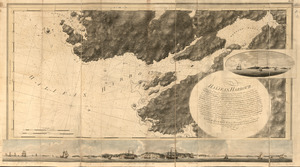
Halifax Harbour ... Catch Harbour ...
66.
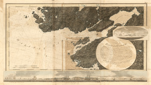
Halifax Harbour ... Catch Harbour ...
67.
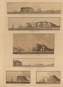
The isle Haut ...; and Cape Chignecto ... ; The western cliffs of Cape Dore ; A view of Cape Baptist in the entrance into the...
68.
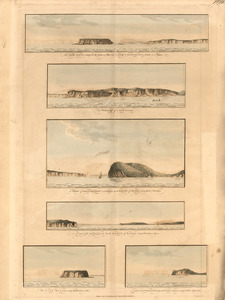
The isle Haut ...; and Cape Chignecto ... ; The western cliffs of Cape Dore ; A view of Cape Baptist in the entrance into the...
69.
The isthmus of Nova Scotia
70.
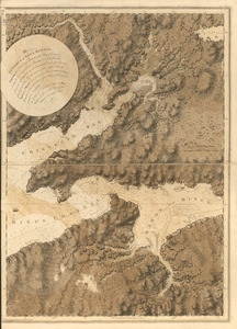
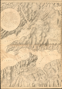
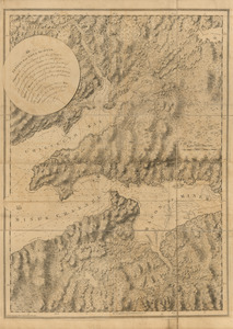
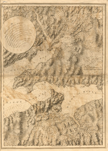
The isthmus of Nova Scotia
71.
The isthmus of Nova Scotia
72.
The isthmus of Nova Scotia
73.
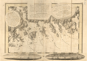
Keppell Harbour ; Knowles Harbour ; Tangier Harbour ; Saunder's Harbour ; Deane Harbour
74.
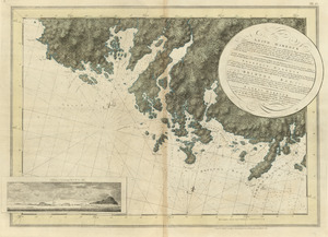
Leith Harbour ; Prospect Harbour ; Bristol Bay ; Sambro Harbour
75.
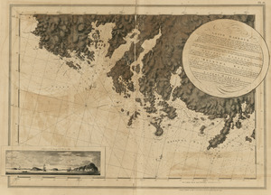
Leith Harbour ; Prospect Harbour ; Bristol Bay ; Sambro Harbour
76.
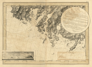
Leith Harbour ; Prospect Harbour ; Bristol Bay ; Sambro Harbour
77.
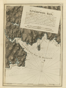
Liverpool Bay
78.
A Map of forty miles north, thirty miles west, and twentyfive miles south of Boston : including an accurate draft of the...
79.
Map of the environs of Roxbury showing roads to Jamaica, Cambridge, Dorchester, Milton, etc
80.
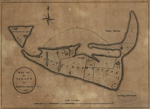
Map of the island of Nantucket
‹ Prev
Next ›
1
2
3
4
5
6
7
8