Toggle navigation
LMEC Home
Exhibitions
Georeferencing
Tools for Teachers
Collections
My Favorites
Sign Up / Log In
Search
Search the map portal
Map Collection
Map Collection
Map Sets
Search
Search
Search for
Search In
All Fields
Creator
Title
Subject
Place
Search All Digital Collections
Advanced Search
170 Results
My Search
Start Over
More Like
commonwealth:z603vj01p
Remove constraint More Like: commonwealth:z603vj01p
Filter your Search
Place
North and Central America
131
United States
81
Canada
61
Suffolk (county)
39
Boston
38
Massachusetts
32
Nova Scotia
21
New England
16
more
Place
»
Topic
Coasts--Nova Scotia--Maps
62
Massachusetts--Maps--Early works to 1800
31
Boston (Mass.)--Buildings, structures, etc--Maps, Manuscript--Early works to 1800
17
Fortification--Massachusetts--Boston--Maps, Manuscript--Early works to 1800
11
Coasts--Nova Scotia--Pictorial works
10
Rhode Island--Maps--Early works to 1800
10
Atlantic Coast (N.S.)--Maps
8
Boston (Mass.)--History--Siege, 1775-1776--Maps, Manuscript--Early works to 1800
8
more
Topic
»
Date
Date range begin
–
Date range end
Current results range from
1634
to
1889
View distribution
Creator
Des Barres, Joseph F. W. (Joseph Frederick Wallet), 1722-1824
99
Montrésor, John, 1736-1799
5
Page, Thomas Hyde, Sir, 1746-1821
4
Bew, John, -1793
3
Lodge, John, -1796
3
Mitchell, George, -1755
3
Bellamie, John, -1654
2
Bowles, Carington, 1724-1793
2
more
Creator
»
Format
Maps/Atlases
169
Manuscripts
36
Prints
1
Georeferenced
Yes
5
No
165
Collection
American Revolutionary War-Era Maps
164
Library of Congress Collection
136
Boston and New England Maps
22
Norman B. Leventhal Map & Education Center Collection
22
Sidney R. Knafel Map Collection at Phillips Academy
6
Maritime Charts and Atlases
4
British Library Collection
3
Mapping Boston Collection
3
more
Collection
»
Available to use
Creative Commons license
144
No known restrictions
19
Search Constraints
Sort by relevance
relevance
title
date (asc)
date (desc)
Number of results to display per page
20 per page
10
per page
20
per page
50
per page
100
per page
View results as:
grid view
map view
Search Results
141.
South entrance of Grand Passage ; Cape St. Mary n.e. one mile ; St. Marys Bay
142.
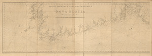
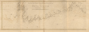
The south west coast of the peninsula of Nova Scotia
143.
The south west coast of the peninsula of Nova Scotia
144.
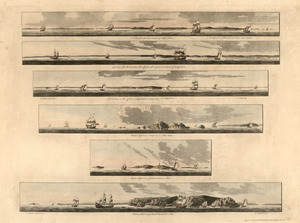
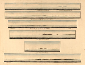
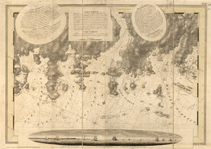
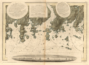
[Southwest coast of Nova Scotia from Cape Sable to Cape St. Mary]
145.
[Southwest coast of Nova Scotia from Cape Sable to Cape St. Mary]
146.
Spry Harbour ; Port Pallisser ; Port North ; Port Parker ; Beaver Harbour ; Fleming River
147.
Spry Harbour ; Port Pallisser ; Port North ; Port Parker ; Beaver Harbour ; Fleming River
148.
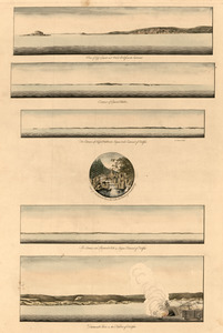
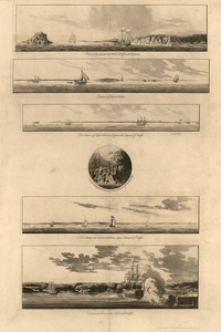
A Temporary project for a star redout [sic] to contain 150 men
149.
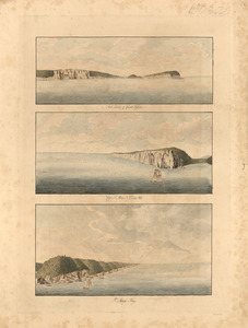
[Torbay]
150.
[Torbay]
151.
[Torbay]
152.
[Torbay]
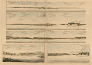
153.
A view from the south eastward of Halifax Harbor ; Appearance of the shore at three miles off four or five leagues to the...
154.
A view from the south eastward of Halifax Harbor ; Appearance of the shore at three miles off four or five leagues to the...
155.
View of Cape Egmont and Winter Rock from the eastward ; Entrance of Egmont Harbor ; The entrance of Keppel Harbor ... ; Falls...
156.
View of Cape Egmont and Winter Rock from the eastward ; Entrance of Egmont Harbor ; The entrance of Keppel Harbor ... ; Falls...
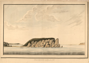
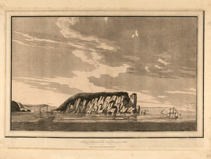
157.
A view of Partridge Island, from the west
158.
A view of Partridge Island, from the west
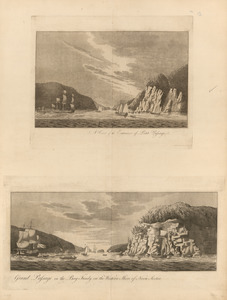
159.
View of the entrance into Annapolis Bason ; View of the north entrance of Grand Passage ; View of Eden and Gascoyne Rivers ......
160.
A view of the entrance of Petit Passage ; Grand Passage in the Bay Fundy, on the western shore of Nova Scotia
‹ Prev
Next ›
1
2
…
4
5
6
7
8
9
![[Southwest coast of Nova Scotia from Cape Sable to Cape St. Mary]](https://bpldcassets.blob.core.windows.net/derivatives/images/commonwealth:t722hs70t/image_thumbnail_300.jpg)
![[Southwest coast of Nova Scotia from Cape Sable to Cape St. Mary]](https://bpldcassets.blob.core.windows.net/derivatives/images/commonwealth:t722hs72c/image_thumbnail_300.jpg)
![A Temporary project for a star redout [sic] to contain 150 men](https://bpldcassets.blob.core.windows.net/derivatives/images/commonwealth:z603vj703/image_thumbnail_300.jpg)
![[Torbay]](https://bpldcassets.blob.core.windows.net/derivatives/images/commonwealth:z603vj95z/image_thumbnail_300.jpg)
![[Torbay]](https://bpldcassets.blob.core.windows.net/derivatives/images/commonwealth:z603vj992/image_thumbnail_300.jpg)
![[Torbay]](https://bpldcassets.blob.core.windows.net/derivatives/images/commonwealth:z603vk01w/image_thumbnail_300.jpg)
![[Torbay]](https://bpldcassets.blob.core.windows.net/derivatives/images/commonwealth:z603vj97h/image_thumbnail_300.jpg)