Toggle navigation
LMEC Home
Exhibitions
Georeferencing
Tools for Teachers
Collections
My Favorites
Sign Up / Log In
Search
Search the map portal
Map Collection
Map Collection
Map Sets
Search
Search
Search for
Search In
All Fields
Creator
Title
Subject
Place
Search All Digital Collections
Advanced Search
8700 Results
My Search
Start Over
More Like
commonwealth:xg94j1388
Remove constraint More Like: commonwealth:xg94j1388
Filter your Search
Place
North and Central America
5,927
United States
4,844
Massachusetts
2,079
Europe
1,396
Suffolk (county)
1,046
Boston
1,019
Canada
449
Asia
438
more
Place
»
Topic
Boston (Mass.)--Maps
586
United States--Maps
282
Real property--Massachusetts--Boston--Maps
175
Massachusetts--Maps
162
Landowners--Massachusetts--Boston--Maps
133
North America--Maps--Early works to 1800
103
New England--Maps
102
Europe--Maps
79
more
Topic
»
Date
Date range begin
–
Date range end
Current results range from
1482
to
2023
View distribution
Creator
United States. Hydrographic Office
595
O.H. Bailey & Co
148
Des Barres, Joseph F. W. (Joseph Frederick Wallet), 1722-1824
123
United States. Post Office Dept
120
Ptolemy, 2nd cent
100
Walling, Henry Francis, 1825-1888
94
Geological Survey (U.S.)
86
Jefferys, Thomas, -1771
85
more
Creator
»
Format
Maps/Atlases
8,640
Manuscripts
215
Prints
56
Books
36
Objects/Artifacts
10
Drawings/Illustrations
8
Posters
5
Georeferenced
Yes
870
No
7,830
Collection
Norman B. Leventhal Map & Education Center Collection
8,695
Boston and New England Maps
2,233
Urban Maps
2,023
Maritime Charts and Atlases
1,083
American Revolutionary War-Era Maps
620
Boston Redevelopment Authority Collection
87
American Antiquarian Society Collection
4
MacLean Collection Map Library
1
Available to use
No known restrictions
8,553
Creative Commons license
47
Search Constraints
Sort by relevance
relevance
title
date (asc)
date (desc)
Number of results to display per page
20 per page
10
per page
20
per page
50
per page
100
per page
View results as:
grid view
map view
Search Results
1.
United Provinces
2.
Richard Mayer's commercial map of Northern Chili, Bolivia & southern Peru
3.
Brazil, Bolivia, & Peru
4.
Peru and Bolivia
5.
Rand, McNally & Co.'s indexed atlas of the world map of Bolivia, Ecuador, and Peru
6.
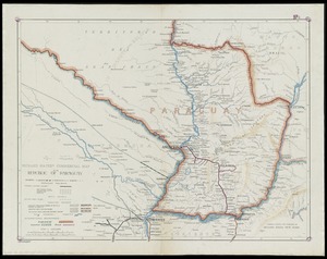
Richard Mayer's commercial map of the republic of Paraguay
7.
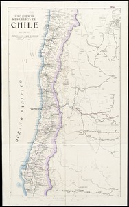
Mapa comercial de la República de Chile
8.
South America, west coast : republication of Brit. Admty. chart no. 1374, with additions to 1876
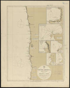
9.
South America, west coast, sheet 10, Bolivia and Peru, C.S. Francisco to Cape Lobos : republication of Brit. Admty. chart no....
10.
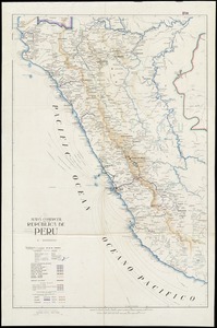
Mapa comercial de la república de Peru
11.
Peru
12.
Argentine railways, 1907
13.
Karte der südlichen provinzen der Argentinischen Republik, zu seiner reise durch die La Plata-Staaten entworfen von Dr. Herm....
14.
A map of part of the Viceroyalty of Buenos Ayres 1806
15.
Mapa de la República de Bolivia : mandado organizar y publicar por el Presidente Constitucional General José Manuel Pando
16.
Mapa geográfico de la Republica Argentina : compilado sobre la base de los datos mas recientes
17.
Mapa-relieve de la República Argentina construido segun los ultimos datos y documentos ineditos de propiedad del establecimiento
18.
Triangulacion de la provincia de Santa Fé
19.
Amérique méridionale : publiée sous les auspices de Monseigneur le Duc d'Orleans prémier prince du Sang
20.
Carte générale de L'Amérique Méridionale et des îles qui en dépendent
‹ Prev
Next ›
1
2
3
4
5
…
434
435