Toggle navigation
LMEC Home
Exhibitions
Georeferencing
Tools for Teachers
Collections
My Favorites
Sign Up / Log In
Search
Search the map portal
Map Collection
Map Collection
Map Sets
Search
Search
Search for
Search In
All Fields
Creator
Title
Subject
Place
Search All Digital Collections
Advanced Search
8695 Results
My Search
Start Over
More Like
commonwealth:x633fb460
Remove constraint More Like: commonwealth:x633fb460
Filter your Search
Place
North and Central America
5,927
United States
4,844
Massachusetts
2,079
Europe
1,396
Suffolk (county)
1,046
Boston
1,019
Canada
449
Asia
438
more
Place
»
Topic
Boston (Mass.)--Maps
586
United States--Maps
282
Real property--Massachusetts--Boston--Maps
175
Massachusetts--Maps
162
Landowners--Massachusetts--Boston--Maps
133
North America--Maps--Early works to 1800
103
New England--Maps
102
Europe--Maps
79
more
Topic
»
Date
Date range begin
–
Date range end
Current results range from
1482
to
2023
View distribution
Creator
United States. Hydrographic Office
595
O.H. Bailey & Co
148
Des Barres, Joseph F. W. (Joseph Frederick Wallet), 1722-1824
123
United States. Post Office Dept
120
Ptolemy, 2nd cent
100
Walling, Henry Francis, 1825-1888
94
Geological Survey (U.S.)
86
Jefferys, Thomas, -1771
85
more
Creator
»
Format
Maps/Atlases
8,635
Manuscripts
215
Prints
56
Books
36
Objects/Artifacts
10
Drawings/Illustrations
8
Posters
5
Georeferenced
Yes
869
No
7,826
Collection
Norman B. Leventhal Map & Education Center Collection
8,694
Boston and New England Maps
2,233
Urban Maps
2,023
Maritime Charts and Atlases
1,083
American Revolutionary War-Era Maps
617
Boston Redevelopment Authority Collection
87
Maps from AAS
1
Available to use
No known restrictions
8,552
Creative Commons license
47
Search Constraints
Sort by relevance
relevance
title
date (asc)
date (desc)
Number of results to display per page
20 per page
10
per page
20
per page
50
per page
100
per page
View results as:
grid view
map view
Search Results
8361.
View of Wallingford, Connecticut : 1881
8362.
View of Waltham, Mass
8363.
View of Warren, Mass : 1879
8364.
View of Warren, R.I : 1877
8365.
View of Watertown, Mass : 1879
8366.
View of Webster, Mass : 1878
8367.
View of Westerly, R.I : 1877
8368.
View of Westport, Conn : 1878
8369.
View of Whitman and Brockton, showing location of some of the most desirable building lots, for sale by W.V. Everson, 120...
8370.
View of Winchendon, Mass : 1878
8371.
View of Winsted, Conn : 1877
8372.
View showing the works of D.S. Morgan & Co., Brockport, N.Y
8373.
Views of London in 1616 and 1890
8374.
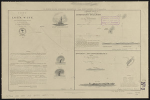
Views of Lot's Wife, taken from Meares' Voyage and from the sketch-book of the U.S. Ship Vincennes, November 1854 ; Borodino...
8375.
Views of Lot's Wife, taken from Meares' Voyage and from the sketch-book of the U.S. Ship Vincennes, November 1854 ; Borodino...
8376.
Views of the area around Dudley Station in Roxbury
8377.
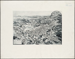
Views of the Boston Harbor Islands
8378.
[Views of the Boston Harbor Islands]
8379.
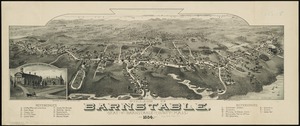
Village of Barnstable, seat of Barnstable County, Mass : 1884
8380.
Village of Kingston, Plymouth County, Mass : 1885
‹ Prev
Next ›
1
2
…
415
416
417
418
419
420
421
422
423
…
434
435


![[Views of the Boston Harbor Islands]](https://bpldcassets.blob.core.windows.net/derivatives/images/commonwealth:1v53jx85b/image_thumbnail_300.jpg)