Toggle navigation
LMEC Home
Exhibitions
Georeferencing
Tools for Teachers
Collections
My Favorites
Sign Up / Log In
Search
Search the map portal
Map Collection
Map Collection
Map Sets
Search
Search
Search for
Search In
All Fields
Creator
Title
Subject
Place
Search All Digital Collections
Advanced Search
8939 Results
My Search
Start Over
More Like
commonwealth:wd376704k
Remove constraint More Like: commonwealth:wd376704k
Filter your Search
Place
North and Central America
6,170
United States
5,072
Massachusetts
2,200
Europe
1,396
Suffolk (county)
1,215
Boston
1,188
Canada
450
Asia
438
more
Place
»
Topic
Boston (Mass.)--Maps
752
United States--Maps
282
Massachusetts--Maps
235
Real property--Massachusetts--Boston--Maps
195
City planning--Massachusetts--Boston--Maps
162
Landowners--Massachusetts--Boston--Maps
142
New England--Maps
106
North America--Maps--Early works to 1800
103
more
Topic
»
Date
Date range begin
–
Date range end
Current results range from
1482
to
2023
View distribution
Creator
United States. Hydrographic Office
595
Boston Redevelopment Authority
168
O.H. Bailey & Co
148
Des Barres, Joseph F. W. (Joseph Frederick Wallet), 1722-1824
124
United States. Post Office Dept
120
Ptolemy, 2nd cent
100
Walling, Henry Francis, 1825-1888
95
Geological Survey (U.S.)
92
more
Creator
»
Format
Maps/Atlases
8,878
Manuscripts
217
Prints
56
Books
36
Objects/Artifacts
10
Drawings/Illustrations
8
Posters
5
Ephemera
1
Georeferenced
Yes
894
No
8,045
Collection
Norman B. Leventhal Map & Education Center Collection
8,766
Boston and New England Maps
2,410
Urban Maps
2,148
Maritime Charts and Atlases
1,083
American Revolutionary War-Era Maps
657
Boston Redevelopment Authority Collection
200
David Judkins Weaver Papers
22
Mapping Boston Collection
22
more
Collection
»
Available to use
No known restrictions
8,714
Creative Commons license
73
Search Constraints
Sort by relevance
relevance
title
date (asc)
date (desc)
Number of results to display per page
20 per page
10
per page
20
per page
50
per page
100
per page
View results as:
grid view
map view
Search Results
2941.
Eldridge's chart of Long Island Sound from Newport to New York
2942.
Eldridge's map of Martha's Vineyard
2943.
Eldridge's new chart no. 4 Boston Harbor : compiled from the latest surveys
2944.
Eldridge's new chart of Boston Harbor : compiled from the latest surveys
2945.
Election map of the United States with 49 novel diagrams
2946.
Electoral vote for President, 1789
2947.
Electoral vote for President, 1792
2948.
Electoral vote for President, 1796
2949.
Electoral votes for President in 1916 and for Congress in 1918 : make your guess for 1920
2950.
Electoratus et Palatinatus Rheni Episcopatuum Spirensis et Wormacensis ducatuum Bipontii et Simmerae et Comitatuum...
2951.
Electric railway map of eastern New England
2952.
Electric transmission systems of the United States, showing all transmission lines and interconnections above 11,000 volts also...
2953.
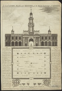
An elevation, plan, and history, of the Royal Exchange of London
2954.
Elihu Geer Sons new map of East Hartford, Connecticut
2955.
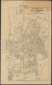
Elihu Geer sons' new map of the city of Hartford, Connecticut
2956.
Elihu Geer's sons' new map of Hartford from the latest surveys
2957.
Elihu Geer's sons' new map of Hartford from the latest surveys
2958.
Elizabeth Islands : Vineyard Sound the property of James Temple-Bowdoin Esq. : 1836
2959.
The embankment and park on Charles River Bay
2960.
The empire of Germany : divided into its general and perticuler parts & most humbly inscrib'd to ye most noble Lord Christopher...
‹ Prev
Next ›
1
2
…
144
145
146
147
148
149
150
151
152
…
446
447