Toggle navigation
LMEC Home
Exhibitions
Georeferencing
Tools for Teachers
Collections
My Favorites
Sign Up / Log In
Search
Search the map portal
Map Collection
Map Collection
Map Sets
Search
Search
Search for
Search In
All Fields
Creator
Title
Subject
Place
Search All Digital Collections
Advanced Search
8931 Results
My Search
Start Over
More Like
commonwealth:wd376690f
Remove constraint More Like: commonwealth:wd376690f
Filter your Search
Place
North and Central America
6,162
United States
5,066
Massachusetts
2,203
Europe
1,396
Suffolk (county)
1,207
Boston
1,180
Canada
450
Asia
438
more
Place
»
Topic
Boston (Mass.)--Maps
752
United States--Maps
282
Massachusetts--Maps
235
Real property--Massachusetts--Boston--Maps
195
City planning--Massachusetts--Boston--Maps
157
Landowners--Massachusetts--Boston--Maps
142
New England--Maps
106
North America--Maps--Early works to 1800
103
more
Topic
»
Date
Date range begin
–
Date range end
Current results range from
1482
to
2023
View distribution
Creator
United States. Hydrographic Office
595
Boston Redevelopment Authority
162
O.H. Bailey & Co
148
Des Barres, Joseph F. W. (Joseph Frederick Wallet), 1722-1824
124
United States. Post Office Dept
120
Ptolemy, 2nd cent
100
Walling, Henry Francis, 1825-1888
95
Geological Survey (U.S.)
92
more
Creator
»
Format
Maps/Atlases
8,870
Manuscripts
217
Prints
56
Books
36
Objects/Artifacts
10
Drawings/Illustrations
8
Posters
5
Ephemera
1
Georeferenced
Yes
894
No
8,037
Collection
Norman B. Leventhal Map & Education Center Collection
8,764
Boston and New England Maps
2,402
Urban Maps
2,143
Maritime Charts and Atlases
1,083
American Revolutionary War-Era Maps
657
Boston Redevelopment Authority Collection
194
Mapping Boston Collection
22
Applied Geographics, Inc. Records
21
more
Collection
»
Available to use
No known restrictions
8,706
Creative Commons license
73
Search Constraints
Sort by relevance
relevance
title
date (asc)
date (desc)
Number of results to display per page
20 per page
10
per page
20
per page
50
per page
100
per page
View results as:
grid view
map view
Search Results
2421.
[City of Niagara Falls]
2422.
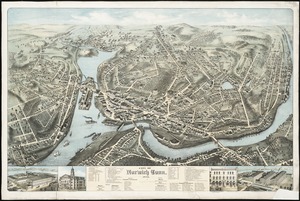
City of Norwich, Conn : 1876
2423.
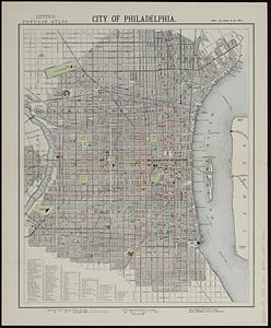
City of Philadelphia
2424.
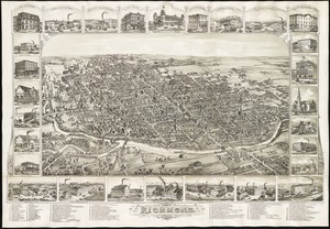
The city of Richmond, Indiana : 1884
2425.
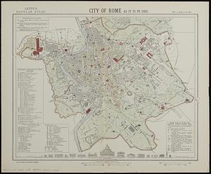
City of Rome as it is in 1882
2426.
City of Salem
2427.
City of San Francisco and its vicinity, California
2428.
City of Somerville : ward 3 : voting precincts
2429.
City of Spokane, 1910, Washington : from official records
2430.
The city of St. John : New Brunswick
2431.
City of Taunton
2432.
City of Taunton, Mass : 1875
2433.
City of Toronto : compiled from surveys made to the present date
2434.
City of Toronto, reduced by permission from Wadsworth & Unwin's large map
2435.
City of Utica
2436.
The city of Vineland, New Jersey : 1885
2437.
City of Washington
2438.
City of White Plains, Westchester County, New York
2439.
The city of Worcester, Mass : 1878
2440.
Civil airways of the United States as designated in Civil Air Regulations - chapter 60
‹ Prev
Next ›
1
2
…
118
119
120
121
122
123
124
125
126
…
446
447
![[City of Niagara Falls]](https://bpldcassets.blob.core.windows.net/derivatives/images/commonwealth:4m90f177c/image_thumbnail_300.jpg)