Toggle navigation
LMEC Home
Exhibitions
Georeferencing
Tools for Teachers
Collections
My Favorites
Sign Up / Log In
Search
Search the map portal
Map Collection
Map Collection
Map Sets
Search
Search
Search for
Search In
All Fields
Creator
Title
Subject
Place
Search All Digital Collections
Advanced Search
8792 Results
My Search
Start Over
More Like
commonwealth:m900rb071
Remove constraint More Like: commonwealth:m900rb071
Filter your Search
Place
North and Central America
6,086
United States
5,008
Massachusetts
2,114
Europe
1,359
Suffolk (county)
1,259
Boston
1,232
Canada
448
Asia
422
more
Place
»
Topic
Boston (Mass.)--Maps
746
United States--Maps
278
Real property--Massachusetts--Boston--Maps
254
City planning--Massachusetts--Boston--Maps
187
Landowners--Massachusetts--Boston--Maps
170
Massachusetts--Maps
164
New England--Maps
103
North America--Maps--Early works to 1800
103
more
Topic
»
Date
Date range begin
–
Date range end
Current results range from
1482
to
2023
View distribution
Creator
United States. Hydrographic Office
594
Boston Redevelopment Authority
193
O.H. Bailey & Co
148
Des Barres, Joseph F. W. (Joseph Frederick Wallet), 1722-1824
124
United States. Post Office Dept
120
Ptolemy, 2nd cent
100
Walling, Henry Francis, 1825-1888
94
Geological Survey (U.S.)
87
more
Creator
»
Format
Maps/Atlases
8,733
Manuscripts
215
Prints
56
Books
36
Objects/Artifacts
10
Drawings/Illustrations
8
Posters
4
Georeferenced
Yes
885
No
7,907
Collection
Norman B. Leventhal Map & Education Center Collection
8,595
Boston and New England Maps
2,368
Urban Maps
2,093
Maritime Charts and Atlases
1,081
American Revolutionary War-Era Maps
638
Boston Redevelopment Authority Collection
224
Massachusetts Real Estate Atlases
38
Mapping Boston Collection
20
more
Collection
»
Available to use
No known restrictions
8,570
Creative Commons license
69
Search Constraints
Sort by relevance
relevance
title
date (asc)
date (desc)
Number of results to display per page
20 per page
10
per page
20
per page
50
per page
100
per page
View results as:
grid view
map view
Search Results
1701.
Buckingamiae comitatus cum Bedfordiensi : vulgo Buckingamshire and Bedfordshire
1702.
Buctouche, New Brunswick
1703.
Buenos Aires
1704.
Buffalo County, Wis.
1705.
Buffalo Harbor and head of Niagara River
1706.
The Builder map of the county of London : shewing the boundaries of the surveyors' districts under the building acts
1707.
The Builder map of the county of London : shewing the boundaries of the surveyors' districts under the building acts
1708.
Building deficiencies map : Government Center project no. Mass. R-35
1709.
Burmah
1710.
Burnett County, Wis.
1711.
Buy homes of J.W. Wilbur & Co.
1712.
Buzzards Bay
1713.
[Buzzards Bay and Vineyard Sound]
1714.
[Buzzards Bay and Vineyard Sound]
1715.
Buzzards Bay, Mass
1716.
Caerte van de Rivier Demerary van ouds Immenary, geleger op Suyd Americaes Noordkust, op de Noorder Breedte van 6 Gr. 40
1717.
Caerte van de voornaemste reysen ende ontdeckingen door de Hollanders gedaen, alsook vande landen, plaetsen ende factoriën in...
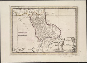
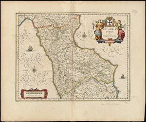
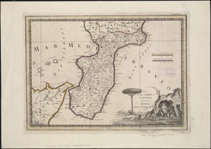
1718.
La Calabria citeriore
1719.
Calabria citra olim magna Graecia
1720.
La Calabria ulteriore
‹ Prev
Next ›
1
2
…
82
83
84
85
86
87
88
89
90
…
439
440