Toggle navigation
LMEC Home
Exhibitions
Georeferencing
Tools for Teachers
Collections
My Favorites
Sign Up / Log In
Search
Search the map portal
Map Collection
Map Collection
Map Sets
Search
Search
Search for
Search In
All Fields
Creator
Title
Subject
Place
Search All Digital Collections
Advanced Search
9012 Results
My Search
Start Over
More Like
commonwealth:jw82df15t
Remove constraint More Like: commonwealth:jw82df15t
Filter your Search
Place
North and Central America
6,242
United States
5,158
Massachusetts
2,163
Europe
1,396
Suffolk (county)
1,332
Boston
1,305
Canada
450
Asia
438
more
Place
»
Topic
Boston (Mass.)--Maps
752
United States--Maps
282
City planning--Massachusetts--Boston--Maps
252
Real property--Massachusetts--Boston--Maps
230
Landowners--Massachusetts--Boston--Maps
169
Massachusetts--Maps
166
Urban renewal--Massachusetts--Boston--Maps
155
Buildings--Massachusetts--Boston--Maps
125
more
Topic
»
Date
Date range begin
–
Date range end
Current results range from
1482
to
2023
View distribution
Creator
United States. Hydrographic Office
595
Boston Redevelopment Authority
253
O.H. Bailey & Co
148
Des Barres, Joseph F. W. (Joseph Frederick Wallet), 1722-1824
124
United States. Post Office Dept
120
Ptolemy, 2nd cent
100
Walling, Henry Francis, 1825-1888
94
Geological Survey (U.S.)
87
more
Creator
»
Format
Maps/Atlases
8,952
Manuscripts
218
Prints
56
Books
36
Objects/Artifacts
10
Drawings/Illustrations
8
Posters
5
Georeferenced
Yes
885
No
8,127
Collection
Norman B. Leventhal Map & Education Center Collection
8,724
Boston and New England Maps
2,457
Urban Maps
2,240
Maritime Charts and Atlases
1,083
American Revolutionary War-Era Maps
662
Boston Redevelopment Authority Collection
289
Massachusetts Real Estate Atlases
38
William L. Clements Library Collection
27
more
Collection
»
Available to use
No known restrictions
8,767
Creative Commons license
71
Search Constraints
Sort by relevance
relevance
title
date (asc)
date (desc)
Number of results to display per page
20 per page
10
per page
20
per page
50
per page
100
per page
View results as:
grid view
map view
Search Results
521.
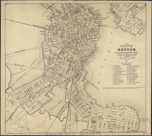
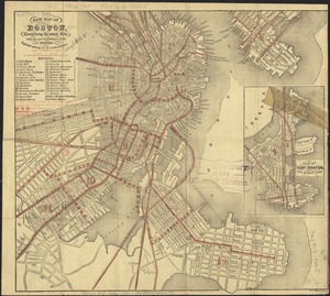
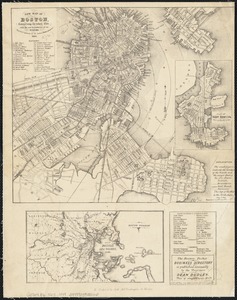
New map of Boston, comprising the whole city, with the new boundaries of the wards
522.
New map of Boston, comprising the whole city, with the new boundaries of the wards
523.
New map of Boston, comprising the whole city, with the new boundaries of the wards
524.
New map of Boston, comprising the whole city, with the new boundaries of the wards
525.
New map of Boston, comprising the whole city, with the new boundaries of the wards
526.
New map of Boston, comprising the whole city, with the new boundaries of the wards
527.
New map of Boston, comprising the whole city, with the new boundaries of the wards
528.
New map of Boston, comprising the whole city, with the new boundaries of the wards
529.
New map of Boston, comprising the whole city, with the new boundaries of the wards
530.
New map of Boston, comprising the whole city with the new boundariess of the wards
531.
New map of Boston from latest surveys
532.
New map of Boston giving all points of interest : with every railway & steamboat terminus, prominent hotels, theatres & public...
533.
New map of Boston giving all points of interest : with every railway & steamboat terminus, prominent hotels, theatres & public...
534.
New map of Boston giving all points of interest : with every railway & steamboat terminus, prominent hotels, theatres & public...
535.
New map of the central portion of Boston
536.
New map of the vicinity of Boston, with the dates of settlement and distance from the capital
537.
New map of the vicinity of Boston, with the dates of settlement and distance from the capital
538.
New map of the vicinity of Boston, with the dates of settlement, population in 1840, and distance from the capital
539.
A new plan of Boston : drawn from the best authorities with the latest improvements, additionas and corrections
540.
Official map of Boston
‹ Prev
Next ›
1
2
…
23
24
25
26
27
28
29
30
31
…
450
451