Toggle navigation
LMEC Home
Exhibitions
Georeferencing
Tools for Teachers
Collections
My Favorites
Sign Up / Log In
Search
Search the map portal
Map Collection
Map Collection
Map Sets
Search
Search
Search for
Search In
All Fields
Creator
Title
Subject
Place
Search All Digital Collections
Advanced Search
8902 Results
My Search
Start Over
More Like
commonwealth:js956k387
Remove constraint More Like: commonwealth:js956k387
Filter your Search
Place
North and Central America
6,133
United States
5,049
Massachusetts
2,133
Europe
1,396
Suffolk (county)
1,248
Boston
1,221
Canada
449
Asia
438
more
Place
»
Topic
Boston (Mass.)--Maps
752
United States--Maps
282
Real property--Massachusetts--Boston--Maps
226
City planning--Massachusetts--Boston--Maps
171
Landowners--Massachusetts--Boston--Maps
169
Massachusetts--Maps
166
New England--Maps
104
North America--Maps--Early works to 1800
103
more
Topic
»
Date
Date range begin
–
Date range end
Current results range from
1482
to
2023
View distribution
Creator
United States. Hydrographic Office
595
Boston Redevelopment Authority
176
O.H. Bailey & Co
148
Des Barres, Joseph F. W. (Joseph Frederick Wallet), 1722-1824
124
United States. Post Office Dept
120
Ptolemy, 2nd cent
100
Walling, Henry Francis, 1825-1888
94
Geological Survey (U.S.)
87
more
Creator
»
Format
Maps/Atlases
8,842
Manuscripts
215
Prints
56
Books
36
Objects/Artifacts
10
Drawings/Illustrations
8
Posters
5
Georeferenced
Yes
885
No
8,017
Collection
Norman B. Leventhal Map & Education Center Collection
8,723
Boston and New England Maps
2,372
Urban Maps
2,156
Maritime Charts and Atlases
1,083
American Revolutionary War-Era Maps
638
Boston Redevelopment Authority Collection
206
Massachusetts Real Estate Atlases
38
Mapping Boston Collection
20
more
Collection
»
Available to use
No known restrictions
8,679
Creative Commons license
70
Search Constraints
Sort by relevance
relevance
title
date (asc)
date (desc)
Number of results to display per page
20 per page
10
per page
20
per page
50
per page
100
per page
View results as:
grid view
map view
Search Results
2621.
Density of population, 1820
2622.
Density of population, 1830
2623.
Density of population, 1840
2624.
Density of population, 1850
2625.
Density of population, 1860
2626.
Density of population, 1870
2627.
Density of population, 1880
2628.
Density of population, 1890
2629.
Density of population, 1900
2630.
Density of population, 1910
2631.
Density of population, 1920
2632.
Density of population in greater Tokyo - census of 1926
2633.
Derry Depot, N.H : Rockingham County : 1887
2634.
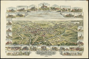
Derry, New Hampshire
2635.
Descriptio Corsicae insulae : Descriptio Sardiniae insulae
2636.
Description du pais de Valois
2637.
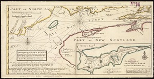
A description of the Bay of Fundy : shewing ye coast, islands, harbours, creeks, coves, rocks & sholes, soundings & anchorings &c
2638.
A description of the towne of Mannados or New Amsterdam : as it was in September, 1661, lying in lattitude 40 de. and 40 m.,...
2639.
A description of the towne of Mannados or New Amsterdam : as it was in September, 1661, lying in lattitude 40 de. and 40 m.,...
2640.
A descriptive map of the region within one hundred miles of the capital of the United States : portraying the principal events...
‹ Prev
Next ›
1
2
…
128
129
130
131
132
133
134
135
136
…
445
446