Toggle navigation
LMEC Home
Exhibitions
Georeferencing
Tools for Teachers
Collections
My Favorites
Sign Up / Log In
Search
Search the map portal
Map Collection
Map Collection
Map Sets
Search
Search
Search for
Search In
All Fields
Creator
Title
Subject
Place
Search All Digital Collections
Advanced Search
614 Results
My Search
Start Over
More Like
commonwealth:hx11z5837
Remove constraint More Like: commonwealth:hx11z5837
Filter your Search
Place
North and Central America
523
United States
247
North America
227
Canada
119
Essex (county)
24
Louisbourg
22
Saint Lawrence River
19
New York
17
more
Place
»
Topic
North America--Maps--Early works to 1800
240
United States--History--French and Indian War, 1754-1763--Maps, Manuscript--Early works to 1800
58
Great Britain--Colonies--America--Maps--Early works to 1800
18
Louisbourg (N.S.)--Maps, Manuscript--Early works to 1800
18
Fort Edward (N.Y.)--Maps, Manuscript--Early works to 1800
16
Fort Ticonderoga (N.Y.)--Maps, Manuscript--Early works to 1800
15
Saint Lawrence River--Maps, Manuscript--Early works to 1800
15
Louisbourg (N.S.)--History--Siege, 1745--Maps, Manuscript--Early works to 1800
14
more
Topic
»
Date
Date range begin
–
Date range end
Current results range from
1528
to
1850
View distribution
Creator
Royal United Services Institute for Defence and Security Studies
160
George, III, King of Great Britain, 1738-1820
152
George, IV, King of Great Britain, 1762-1830
151
Amherst, Jeffery Amherst, Baron, 1717-1797
128
Skinner, Monier
28
Skinner, William, 1700-1780
28
Mitchell, John, 1711-1768
18
Brasier, William
16
more
Creator
»
Format
Maps/Atlases
597
Manuscripts
152
Drawings/Illustrations
15
Georeferenced
Yes
11
No
603
Collection
American Revolutionary War-Era Maps
528
British Library Collection
376
Norman B. Leventhal Map & Education Center Collection
113
MacLean Collection Map Library
59
New York Public Library Collection
32
Boston and New England Maps
21
Richard H. Brown Revolutionary War Map Collection at Mount Vernon
18
Mapping Boston Collection
10
more
Collection
»
Available to use
Creative Commons license
437
No known restrictions
107
Search Constraints
Sort by relevance
relevance
title
date (asc)
date (desc)
Number of results to display per page
20 per page
10
per page
20
per page
50
per page
100
per page
View results as:
grid view
map view
Search Results
221.
Nova tabula geographica complectens borealiorem Americæ partem : in qua exacte delineatæ sunt Canada sive Nova Francia, Nova...
222.
Novissima et accuratissima totius Americae descriptio
223.
La Nuoua Francia
224.
Nuove scoperte de' russi al nord del mare del sud si nell' Asia, che nell America
225.
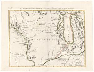
Il paese de' selvagi Outagamiani, Mascoutensi Illinesi e parte delle VI. Nazioni
226.
Partie de l'Amerique Septentrionale, qui comprend le Canada, la Louisiane, le Labrador, le Groenland, la Nouvelle Angleterre,...
227.
Pas-caert van Terra Nova, Nova Francia, Nieuw-Engeland en de groote rivier van Canada
228.
Paskaerte van Nova Granada en t'Eylandt California
229.
Les principales forteresses, ports &c. de l'Amérique septentrionale
230.
Rade et port de Plaisance -- Le Port d'Anapolis dans l'Acadie -- Port de Boston dans la Nouvlle. Angleterre
231.
Regni Mexicani seu Novae Hispaniae, Ludovicianae, N. Angliae, Carolinae, Virginae et Pensylvaniae necnon insularum archipelagi...
232.
Suite du theatre de la guerre dans l'Amerique Septentrionale y compris le Golfe du Mexique
233.
Terra de Lavoratore
234.
Theodolite's pattern, shewing the provinces in North America which were in the respective possessions of England, France &...
235.
This map of North America, according to ye newest and most exact observations is most humbly dedicated by your Lordship's most...
236.
Tierra nueua
237.
Tierra nveva
238.
To the Right Honourable John Lord Sommers, Baron of Evesham in ye county of Worcester, president of Her Majesty's most...
239.
Die vereinigten staaten von Nordamerika
240.
Virginia et Nova Francia
‹ Prev
Next ›
1
2
…
8
9
10
11
12
13
14
15
16
…
30
31