Toggle navigation
LMEC Home
Exhibitions
Georeferencing
Tools for Teachers
Collections
My Favorites
Sign Up / Log In
Search
Search the map portal
Map Collection
Map Collection
Map Sets
Search
Search
Search for
Search In
All Fields
Creator
Title
Subject
Place
Search All Digital Collections
Advanced Search
294 Results
My Search
Start Over
More Like
commonwealth:dz010v34g
Remove constraint More Like: commonwealth:dz010v34g
Filter your Search
Place
North and Central America
227
United States
165
Suffolk (county)
32
New York
31
Boston
30
Canada
27
North America
27
Charleston (county)
10
more
Place
»
Topic
North America--Maps--Early works to 1800
18
Boston (Mass.)--History--Revolution, 1775-1783--Maps--Early works to 1800
16
Vues d'optique
10
Boston (Mass.)--Pictorial works--Early works to 1800
9
Gibraltar--History--Siege, 1779-1783--Maps--Early works to 1800
9
New York (N.Y.)--Pictorial works--Early works to 1800
9
United States--History--French and Indian War, 1754-1763--Maps--Early works to 1800
9
United States--Maps--Early works to 1800
9
more
Topic
»
Date
Date range begin
–
Date range end
Current results range from
1740
to
1799
View distribution
Creator
Faden, William, 1749-1836
33
Jefferys, Thomas, -1771
29
Le Rouge, Georges-Louis
23
Des Barres, Joseph F. W. (Joseph Frederick Wallet), 1722-1824
21
Sayer, Robert, 1725-1794
19
Korn, Christoph Heinrich, 1726-1783
11
Raspe, Gabriel Nicolaus, 1712-1785
11
Simcoe, John Graves, 1752-1806
10
more
Creator
»
Format
Maps/Atlases
252
Prints
31
Manuscripts
23
Drawings/Illustrations
9
Books
2
Georeferenced
Yes
12
No
282
Collection
American Revolutionary War-Era Maps
293
Richard H. Brown Revolutionary War Map Collection at Mount Vernon
293
Boston and New England Maps
5
Urban Maps
3
Maritime Charts and Atlases
2
Norman B. Leventhal Map & Education Center Collection
1
Available to use
Creative Commons license
293
No known restrictions
1
Search Constraints
Sort by relevance
relevance
title
date (asc)
date (desc)
Number of results to display per page
20 per page
10
per page
20
per page
50
per page
100
per page
View results as:
grid view
map view
Search Results
1.
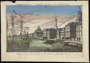
Débarquement des troupes Angloises à Nouvelle Yorck
2.
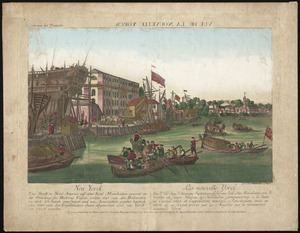
Neu Yorck = : La Nouvelle Yorck
3.
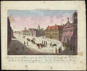
Prospect der grossen plazes gegn der alten Sud Kirche der Presbiterianer zu Boston = : Vuë de la Rue grande vers l'Eglise du...
4.
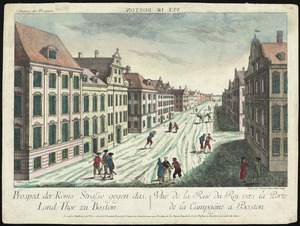
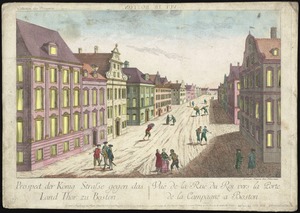
Prospect der König Strasse gegen das land thor zu Boston = : Vuë de la Rue du Roi vers la porte de la campagne a Boston
5.
Prospect der König Strasse gegen das land thor zu Boston = Vuë de la Rue du Roi vers la porte de la campagne a Boston
6.
A view of Boston from Dorchester neck : Long Island open on the north side of Nicks Mate Island ; Boston from Willis Creek
7.
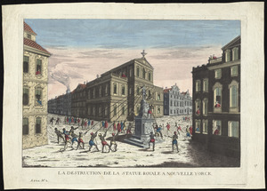
La destruction de la statue royale a Nouvelle Yorck
8.
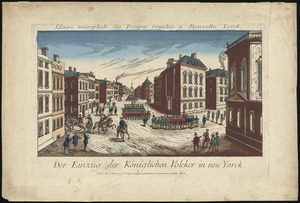
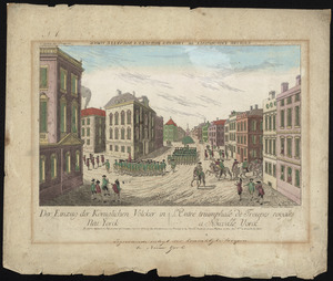
Der einzug der königlichen völcker in Neu Yorck
9.
Der einzug der königlichen völcker in Neu Yorck = : L'entré triumphale de troupes royales á Nouvelle Yorck
10.
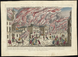
Représentation du feu terrible à Nouvelle Yorck, que les Américains ont allumé pendant la nuit du 19 Septembre 1776 ... et...
11.
Die zerstörung der königlichen bild säule zu Neu Yorck = : La destruction de la statue royale a Nouvelle Yorck
12.
[A map of part of Pennsylvania & Maryland intended to shew, at one view, the several places proposed for opening a...
13.
Abriss der stadt Gibraltar und der darinn befindlichen festen platze, nebst dem meerbusen von Algesiras
14.
An accurate map of His Majesty's province of New-Hampshire in New England : taken from actual surveys of all the inhabited...
15.
An accurate map of Staten Island : with that part of New York, Long Island and the Jerseys, which is the rendesvous of the two...
16.
An accurate map of the country round Boston in New England from the best authorities
17.
Action at Spencer's ordinary : June 26th. 1781
18.
Affair at Quintin's Bridge : 18th March 1778
19.
Allgemeine charte von Nord America als den sitz des krieges zwischen den Konigl. Engl. truppen u:den provinzialen
20.
Ambuscade of the Indians at Kingsbridge : August 31st. 1778
‹ Prev
Next ›
1
2
3
4
5
…
14
15

![[A map of part of Pennsylvania & Maryland intended to shew, at one view, the several places proposed for opening a communication between the waters of the Delaware & Chesopeak Bays]](https://bpldcassets.blob.core.windows.net/derivatives/images/commonwealth:z603vt12v/image_thumbnail_300.jpg)


