Toggle navigation
LMEC Home
Exhibitions
Georeferencing
Tools for Teachers
Collections
My Favorites
Sign Up / Log In
Search
Search the map portal
Map Collection
Map Collection
Map Sets
Search
Search
Search for
Search In
All Fields
Creator
Title
Subject
Place
Search All Digital Collections
Advanced Search
8853 Results
My Search
Start Over
More Like
commonwealth:cj82m562q
Remove constraint More Like: commonwealth:cj82m562q
Filter your Search
Place
North and Central America
6,080
United States
4,926
Massachusetts
2,080
Europe
1,397
Suffolk (county)
1,046
Boston
1,019
Canada
540
Asia
438
more
Place
»
Topic
Boston (Mass.)--Maps
586
United States--Maps
284
Real property--Massachusetts--Boston--Maps
175
Massachusetts--Maps
163
United States--History--French and Indian War, 1754-1763--Maps
162
Landowners--Massachusetts--Boston--Maps
133
New England--Maps
104
North America--Maps--Early works to 1800
103
more
Topic
»
Date
Date range begin
–
Date range end
Current results range from
1482
to
2023
View distribution
Creator
United States. Hydrographic Office
595
O.H. Bailey & Co
148
Des Barres, Joseph F. W. (Joseph Frederick Wallet), 1722-1824
123
United States. Post Office Dept
120
Ptolemy, 2nd cent
100
Jefferys, Thomas, -1771
97
Walling, Henry Francis, 1825-1888
94
Geological Survey (U.S.)
86
more
Creator
»
Format
Maps/Atlases
8,792
Manuscripts
215
Prints
57
Books
36
Objects/Artifacts
10
Drawings/Illustrations
8
Posters
5
Georeferenced
Yes
869
No
7,984
Collection
Norman B. Leventhal Map & Education Center Collection
8,694
Boston and New England Maps
2,233
Urban Maps
2,023
Maritime Charts and Atlases
1,083
American Revolutionary War-Era Maps
774
William L. Clements Library Collection
149
Boston Redevelopment Authority Collection
87
Richard H. Brown Revolutionary War Map Collection at Mount Vernon
5
more
Collection
»
Available to use
No known restrictions
8,553
Creative Commons license
52
Search Constraints
Sort by relevance
relevance
title
date (asc)
date (desc)
Number of results to display per page
20 per page
10
per page
20
per page
50
per page
100
per page
View results as:
grid view
map view
Search Results
7361.
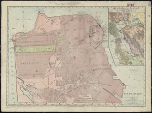
San Francisco
7362.
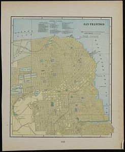
San Francisco ; Mexico
7363.
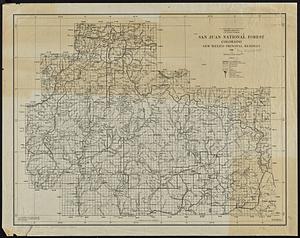
San Juan National Forest, Colorado
7364.
Sandwich Bay ... low water
7365.
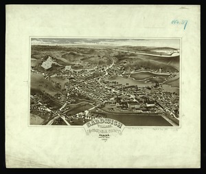
Sandwich Village, Barnstable County, Mass., looking west
7366.
Sandy-Bay, Mass
7367.
Sanford, Maine : looking east
7368.
Santa Barbara National Forest, California (Monterey Division)
7369.
Santiam National Forest, Oregon
7370.
Saratoga Springs and vicinity : scene of the inter-collegiate regatta : [see page 626]
7371.
Saskatchewan
7372.
Saskatchewan : map showing disposition of lands
7373.
Saskatchewan : map showing disposition of lands
7374.
Satsuma, Putnam County, Florida : the property of Whitney, Gold and Hodges
7375.
Sauk County, Wis.
7376.
Sault du Niagara de 135 pieds de haut
7377.
[Scandinavia]
7378.
Scarborough's map of Ontario : with an index of all cities, villages, post-offices and railway stations and population...
7379.
Scarborough's new county and post office map of Louisiana and Mississippi : with complete index giving population and location...
7380.
Scarborough's new county and post office map of Virginia, Maryland, Delaware, and District of Columbia : with complete index...
‹ Prev
Next ›
1
2
…
365
366
367
368
369
370
371
372
373
…
442
443


![[Scandinavia]](https://bpldcassets.blob.core.windows.net/derivatives/images/commonwealth:7h14b059b/image_thumbnail_300.jpg)


