Toggle navigation
LMEC Home
Exhibitions
Georeferencing
Tools for Teachers
Collections
My Favorites
Sign Up / Log In
Search
Search the map portal
Map Collection
Map Collection
Map Sets
Search
Search
Search for
Search In
All Fields
Creator
Title
Subject
Place
Search All Digital Collections
Advanced Search
8807 Results
My Search
Start Over
More Like
commonwealth:cj82kn50n
Remove constraint More Like: commonwealth:cj82kn50n
Filter your Search
Place
North and Central America
6,038
United States
4,931
Massachusetts
2,153
Europe
1,396
Suffolk (county)
1,049
Boston
1,022
Canada
458
Asia
438
more
Place
»
Topic
Boston (Mass.)--Maps
592
United States--Maps
282
Massachusetts--Maps
235
Real property--Massachusetts--Boston--Maps
175
Landowners--Massachusetts--Boston--Maps
133
New England--Maps
127
North America--Maps--Early works to 1800
103
Europe--Maps
79
more
Topic
»
Date
Date range begin
–
Date range end
Current results range from
1482
to
2023
View distribution
Creator
United States. Hydrographic Office
595
O.H. Bailey & Co
148
Des Barres, Joseph F. W. (Joseph Frederick Wallet), 1722-1824
123
United States. Post Office Dept
120
Ptolemy, 2nd cent
100
Walling, Henry Francis, 1825-1888
95
Geological Survey (U.S.)
92
Jefferys, Thomas, -1771
86
more
Creator
»
Format
Maps/Atlases
8,746
Manuscripts
217
Prints
56
Books
36
Objects/Artifacts
10
Drawings/Illustrations
8
Posters
5
Ephemera
1
Georeferenced
Yes
881
No
7,926
Collection
Norman B. Leventhal Map & Education Center Collection
8,740
Boston and New England Maps
2,284
Urban Maps
2,024
Maritime Charts and Atlases
1,083
American Revolutionary War-Era Maps
666
Boston Redevelopment Authority Collection
90
American Antiquarian Society Collection
22
David Judkins Weaver Papers
21
more
Collection
»
Available to use
No known restrictions
8,598
Creative Commons license
54
Search Constraints
Sort by relevance
relevance
title
date (asc)
date (desc)
Number of results to display per page
20 per page
10
per page
20
per page
50
per page
100
per page
View results as:
grid view
map view
Search Results
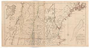
321.
A map of the most inhabited part of New England containing the provinces of Massachusets Bay and New Hampshire with the...
322.
A map of the province of Massachusetts Bay, and colony of Rhode Island, with part of Connecticut, New Hampshire, and Vermont
323.
A Map of the Sea Coasts of NEW ENGLAND According to the actual Survey made thereof BY CAP.T CYPRIAN SOUTHACK As also the...
324.
A new and accurate map of Quebec and its boundaries: from a late survey
325.
A new and accurate map of the present seat of war in North America
326.
New England fishery, recreation and scenic resources
327.
New England regional transportation map = Mapa do transporte regional da Nova Inglaterra = Nueva Inglaterra, mapa regional de...
328.
Old Colony & Newport railway and its connections
329.
The Seat of war, in New England
330.
Sketch A showing the progress of the survey in section no. 1 from 1844 to 1881
331.
A SMALL MAP of the SEA COAST of NEW ENGLAND Together with the out Lines of Several of the Provinces Lying theron. 1738
332.
An accurate map of the commonwealth of Massachusetts exclusive of the district of Maine compiled pursuant to an act of the...
333.
An accurate map of the commonwealth of Massachusetts exclusive of the district of Maine compiled pursuant to an act of the...
334.
Atlas of Massachusetts
335.
Atlas of Massachusetts
336.
Commonwealth of Massachusetts U.S. congressional districts
337.
DFWELE land showing 1985-1990 acquisitions
338.
Eastern encephalitis risk area
339.
EOEA MassGIS geographic information system transition document : The EOEA geographic information system: MassGIS
340.
EOEA wide area network
‹ Prev
Next ›
1
2
…
13
14
15
16
17
18
19
20
21
…
440
441