Toggle navigation
LMEC Home
Exhibitions
Georeferencing
Tools for Teachers
Collections
My Favorites
Sign Up / Log In
Search
Search the map portal
Map Collection
Map Collection
Map Sets
Search
Search
Search for
Search In
All Fields
Creator
Title
Subject
Place
Search All Digital Collections
Advanced Search
8947 Results
My Search
Start Over
More Like
commonwealth:9g54xm00q
Remove constraint More Like: commonwealth:9g54xm00q
Filter your Search
Place
North and Central America
6,178
United States
5,094
Massachusetts
2,172
Europe
1,396
Suffolk (county)
1,293
Boston
1,266
Canada
449
Asia
438
more
Place
»
Topic
Boston (Mass.)--Maps
752
United States--Maps
282
Real property--Massachusetts--Boston--Maps
231
City planning--Massachusetts--Boston--Maps
215
Landowners--Massachusetts--Boston--Maps
169
Massachusetts--Maps
166
Urban renewal--Massachusetts--Boston--Maps
105
New England--Maps
104
more
Topic
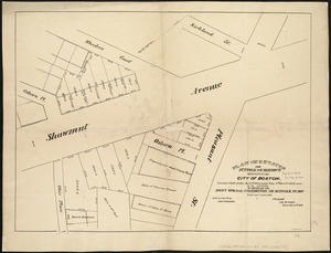
»
Date
Date range begin
–
Date range end
Current results range from
1482
to
2023
View distribution
Creator
United States. Hydrographic Office
595
Boston Redevelopment Authority
216
O.H. Bailey & Co
148
Des Barres, Joseph F. W. (Joseph Frederick Wallet), 1722-1824
124
United States. Post Office Dept
120
Ptolemy, 2nd cent
100
Walling, Henry Francis, 1825-1888
94
Geological Survey (U.S.)
87
more
Creator
»
Format
Maps/Atlases
8,887
Manuscripts
215
Prints
56
Books
36
Objects/Artifacts
10
Drawings/Illustrations
8
Posters
5
Georeferenced
Yes
885
No
8,062
Collection
Norman B. Leventhal Map & Education Center Collection
8,724
Boston and New England Maps
2,417
Urban Maps
2,201
Maritime Charts and Atlases
1,083
American Revolutionary War-Era Maps
638
Boston Redevelopment Authority Collection
250
Massachusetts Real Estate Atlases
38
Mapping Boston Collection
20
more
Collection
»
Available to use
No known restrictions
8,724
Creative Commons license
70
Search Constraints
Sort by relevance
relevance
title
date (asc)
date (desc)
Number of results to display per page
20 per page
10
per page
20
per page
50
per page
100
per page
View results as:
grid view
map view
Search Results
61.
Plan of estates on Suffolk St. District : belonging to the City of Boston : to be sold at public auction, Dec. 23rd 1871
62.
Plan of estates on Suffolk St. district : belonging to the City of Boston : to be sold at public auction on Saturday Dec. 16th...
63.
Plan of lands belonging to the Commonwealth of Massachusetts
64.
[Plan of lots between Mount Vernon and Pinckney Streets in Boston]
65.
[Plan of lots for sale on Morton and Milk Streets, Boston]
66.
[Plan of lots for sale on Pearl Street in Boston]
67.
[Plan of lots in South Boston]
68.
[Plan of lots on Beacon Street and Somerset Court, Boston]
69.
Plan of lots on Fort Hill district, belonging to the City of Boston : to be sold at public auction, on Wednesday, April 15th at...
70.
[Plan of lots on Park, Beacon and Tremont Streets in Boston]
71.
Plan of Mercantile Wharf property in Boston Mass : showing 5 lots of land thereon to be sold at public auction on Tuesday April...
72.
[Plan of part of Boston bounded by Eliot, Washington, and Pleasant streets showing landownership in the late 17th century]
73.
Plan of Quincy House lot, corner of Brattle St. and Brattle Sq. belonging to the estate of Josiah Quincy Jr : to be sold by...
74.
Plan of site for new court house on Pemberton Sq. and Somerset St. for the County of Suffolk : taken by authority of Chapter 377
75.
Plan of the Brooks estate corner of Court & Washington Street : to be sold at public auction, at the Merchants Exchange Reading...
76.
Plan of the city of Boston
77.
Plan of the Federal St. Meeting House estate : to be sold by public auction, on Thursday February 24th 1859, at 12 o'clock noon...
78.
[Plan of the Gore Estate at the corner of Pitts and Green streets]
79.
Plan of the old Julien estate : compriseing [sic] two stores on Milk and Congress Streets : belonging to the estate of the late...
80.
Plan of the Pratt estate, corner of Summer & Hawley Streets : to be sold by pulic auction on Thursday April 10th 1855 at 12...
‹ Prev
Next ›
1
2
3
4
5
6
7
8
…
447
448


![[Plan of lots between Mount Vernon and Pinckney Streets in Boston]](https://bpldcassets.blob.core.windows.net/derivatives/images/commonwealth:9s161h42m/image_thumbnail_300.jpg)
![[Plan of lots for sale on Morton and Milk Streets, Boston]](https://bpldcassets.blob.core.windows.net/derivatives/images/commonwealth:9s161h52v/image_thumbnail_300.jpg)
![[Plan of lots for sale on Pearl Street in Boston]](https://bpldcassets.blob.core.windows.net/derivatives/images/commonwealth:9s161h54d/image_thumbnail_300.jpg)
![[Plan of lots in South Boston]](https://bpldcassets.blob.core.windows.net/derivatives/images/commonwealth:9s161h046/image_thumbnail_300.jpg)
![[Plan of lots on Beacon Street and Somerset Court, Boston]](https://bpldcassets.blob.core.windows.net/derivatives/images/commonwealth:9s161h18j/image_thumbnail_300.jpg)

![[Plan of lots on Park, Beacon and Tremont Streets in Boston]](https://bpldcassets.blob.core.windows.net/derivatives/images/commonwealth:9s161j64v/image_thumbnail_300.jpg)

![[Plan of part of Boston bounded by Eliot, Washington, and Pleasant streets showing landownership in the late 17th century]](https://bpldcassets.blob.core.windows.net/derivatives/images/commonwealth:4m90fp141/image_thumbnail_300.jpg)


![[Plan of the Gore Estate at the corner of Pitts and Green streets]](https://bpldcassets.blob.core.windows.net/derivatives/images/commonwealth:9s161h402/image_thumbnail_300.jpg)

