Toggle navigation
LMEC Home
Exhibitions
Georeferencing
Tools for Teachers
Collections
My Favorites
Sign Up / Log In
Search
Search the map portal
Map Collection
Map Collection
Map Sets
Search
Search
Search for
Search In
All Fields
Creator
Title
Subject
Place
Search All Digital Collections
Advanced Search
1217 Results
My Search
Start Over
More Like
commonwealth:7h14cx71c
Remove constraint More Like: commonwealth:7h14cx71c
Filter your Search
Place
North and Central America
1,213
United States
1,208
Suffolk (county)
1,193
Boston
1,192
Massachusetts
858
Roxbury
82
South End
60
Charlestown
50
more
Place
»
Topic
Boston (Mass.)--Maps
752
City planning--Massachusetts--Boston--Maps
418
Real property--Massachusetts--Boston--Maps
253
Urban renewal--Massachusetts--Boston--Maps
253
Landowners--Massachusetts--Boston--Maps
160
Buildings--Massachusetts--Boston--Maps
120
Land use--Massachusetts--Boston--Maps
102
Roxbury (Boston, Mass.)--Maps
81
more
Topic
»
Date
Date range begin
–
Date range end
Current results range from
1743
to
2023
View distribution
Creator
Boston Redevelopment Authority
389
Bromley, George Washington
69
Bromley, Walter Scott
68
G.W. Bromley & Co.
46
Geo. H. Walker & Co
27
Boynton, George W., d. 1884
21
Sampson, Davenport & Co
21
Sampson, Murdock & Co
20
more
Creator
»
Format
Maps/Atlases
1,216
Manuscripts
10
Drawings/Illustrations
3
Prints
1
Georeferenced
Yes
104
No
1,113
Collection
Boston and New England Maps
1,010
Urban Maps
910
Norman B. Leventhal Map & Education Center Collection
770
Boston Redevelopment Authority Collection
450
Massachusetts Real Estate Atlases
38
American Revolutionary War-Era Maps
26
Mapping Boston Collection
20
William L. Clements Library Collection
10
more
Collection
»
Available to use
No known restrictions
1,121
Creative Commons license
36
Search Constraints
Sort by relevance
relevance
title
date (asc)
date (desc)
Number of results to display per page
20 per page
10
per page
20
per page
50
per page
100
per page
View results as:
grid view
map view
Search Results
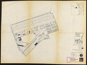
241.
Back Bay urban renewal area r-47 : existing land use
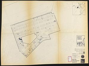
242.
Back Bay urban renewal area r-47 : building conditions
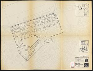
243.
Back Bay urban renewal area r-47 : existing population density
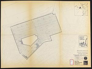
244.
Back Bay urban renewal area r-47 : proposed treatment and title 1 projects
245.
Back Bay urban renewal area r-47 : existing and proposed community facilities
246.
Back Bay zoning district map
247.
Basement plan of terminal station at Boston, Massachusetts, for the N.Y.N.H & H. and B. & A. railroads
248.
Campus High School urban renewal area, Mass. r- : land disposition map
249.
Campus High School urban renewal area Mass. r- : existing land use
250.
Campus High School urban renewal area Mass. r- : building conditions
251.
Campus High School urban renewal area Mass. r-129 : proposed land-use
252.
Campus High School urban renewal area Mass. r-129 : existing land-use
253.
Campus High School urban renewal area Mass. r-129 : existing and proposed zoning
254.
Campus High School urban renewal area Massachusetts R-129 : illustrative site plan
255.
Central business district urban renewal area R-82 : sub area boundaries
256.
Charlestown project no. Mass r-42 (GN) : existing circulation
257.
Charlestown project no. Mass r-42 (GN) : existing zoning
258.
Charlestown project no. Mass r-42 (GN) : generalized building conditions
259.
Charlestown project no. Mass r-42 (GN) : proposed treatment areas and project boundaries
260.
Charlestown project no. Mass r-42 (GN) : population distribution
‹ Prev
Next ›
1
2
…
9
10
11
12
13
14
15
16
17
…
60
61