Toggle navigation
LMEC Home
Exhibitions
Georeferencing
Tools for Teachers
Collections
My Favorites
Sign Up / Log In
Search
Search the map portal
Map Collection
Map Collection
Map Sets
Search
Search
Search for
Search In
All Fields
Creator
Title
Subject
Place
Search All Digital Collections
Advanced Search
8769 Results
My Search
Start Over
More Like
commonwealth:3f463b38r
Remove constraint More Like: commonwealth:3f463b38r
Filter your Search
Place
North and Central America
5,999
United States
4,901
Massachusetts
2,149
Europe
1,396
Suffolk (county)
1,047
Boston
1,020
Canada
450
Asia
438
more
Place
»
Topic
Boston (Mass.)--Maps
590
United States--Maps
282
Massachusetts--Maps
235
Real property--Massachusetts--Boston--Maps
175
Landowners--Massachusetts--Boston--Maps
133
New England--Maps
104
North America--Maps--Early works to 1800
103
Europe--Maps
79
more
Topic
»
Date
Date range begin
–
Date range end
Current results range from
1482
to
2023
View distribution
Creator
United States. Hydrographic Office
595
O.H. Bailey & Co
148
Des Barres, Joseph F. W. (Joseph Frederick Wallet), 1722-1824
123
United States. Post Office Dept
120
Ptolemy, 2nd cent
100
Walling, Henry Francis, 1825-1888
95
Geological Survey (U.S.)
92
Jefferys, Thomas, -1771
85
more
Creator
»
Format
Maps/Atlases
8,707
Manuscripts
217
Prints
57
Books
36
Objects/Artifacts
10
Drawings/Illustrations
8
Posters
5
Ephemera
1
Georeferenced
Yes
879
No
7,890
Collection
Norman B. Leventhal Map & Education Center Collection
8,738
Boston and New England Maps
2,280
Urban Maps
2,024
Maritime Charts and Atlases
1,083
American Revolutionary War-Era Maps
635
Boston Redevelopment Authority Collection
90
Applied Geographics, Inc. Records
20
David Judkins Weaver Papers
18
more
Collection
»
Available to use
No known restrictions
8,596
Creative Commons license
51
Search Constraints
Sort by relevance
relevance
title
date (asc)
date (desc)
Number of results to display per page
20 per page
10
per page
20
per page
50
per page
100
per page
View results as:
grid view
map view
Search Results
3401.
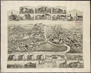
Lonsdale, Rhode Island : 1888
3402.
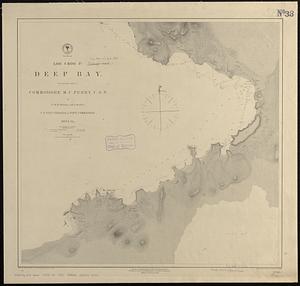
Loo Choo Id., Deep Bay
3403.
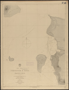
(Loo Choo) Tubootch & Suco Harbors
3404.
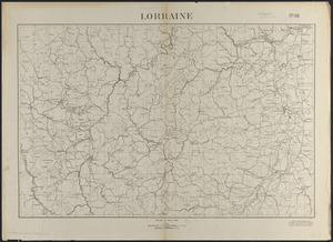
Lorraine
3405.
Lotharingia ducatus noua descriptio
3406.
Lotharingia Ducatus, vulgo Lorraine
3407.
Loto des 5 parties du monde : races humaines, productions, vegetales et animales [cover]
3408.
Louisiana
3409.
Louisiana : Chef Menteur sheet
3410.
Louisiana : Hahnville sheet
3411.
Louisiana : Saint Bernard sheet
3412.
Louisiana : New Orleans sheet
3413.
Louisiana : Spanish Fort sheet
3414.
Louisiana : Bonnet Carre sheet
3415.
Louisiana
3416.
Louisiana, a dream state
3417.
La Louisiana, parte settentrionalle, scoperta sotto la protettione di Luigi XIV, Ré di Francia, etc
3418.
Lovell's map of the city of Montreal : including Westmount, Outremount, Verdun, Montreal West and St. Laurent
3419.
Low Archipelago or Paumotu Group
3420.
Ludlow, Vt
‹ Prev
Next ›
1
2
…
167
168
169
170
171
172
173
174
175
…
438
439