Toggle navigation
LMEC Home
Exhibitions
Georeferencing
Tools for Teachers
Collections
My Favorites
Sign Up / Log In
Search
Search the map portal
Map Collection
Map Collection
Map Sets
Search
Search
Search for
Search In
All Fields
Creator
Title
Subject
Place
Search All Digital Collections
Advanced Search
8741 Results
My Search
Start Over
More Like
commonwealth:3f463701g
Remove constraint More Like: commonwealth:3f463701g
Filter your Search
Place
North and Central America
6,036
United States
4,958
Massachusetts
2,098
Europe
1,359
Suffolk (county)
1,221
Boston
1,194
Canada
448
Asia
422
more
Place
»
Topic
Boston (Mass.)--Maps
740
United States--Maps
273
Real property--Massachusetts--Boston--Maps
222
Landowners--Massachusetts--Boston--Maps
168
Massachusetts--Maps
163
City planning--Massachusetts--Boston--Maps
158
North America--Maps--Early works to 1800
103
New England--Maps
101
more
Topic
»
Date
Date range begin
–
Date range end
Current results range from
1482
to
2023
View distribution
Creator
United States. Hydrographic Office
594
Boston Redevelopment Authority
163
O.H. Bailey & Co
148
Des Barres, Joseph F. W. (Joseph Frederick Wallet), 1722-1824
124
United States. Post Office Dept
120
Ptolemy, 2nd cent
100
Walling, Henry Francis, 1825-1888
94
Geological Survey (U.S.)
87
more
Creator
»
Format
Maps/Atlases
8,682
Manuscripts
215
Prints
56
Books
36
Objects/Artifacts
10
Drawings/Illustrations
8
Posters
4
Georeferenced
Yes
885
No
7,856
Collection
Norman B. Leventhal Map & Education Center Collection
8,575
Boston and New England Maps
2,327
Urban Maps
2,056
Maritime Charts and Atlases
1,081
American Revolutionary War-Era Maps
638
Boston Redevelopment Authority Collection
193
Massachusetts Real Estate Atlases
38
Mapping Boston Collection
20
more
Collection
»
Available to use
No known restrictions
8,519
Creative Commons license
69
Search Constraints
Sort by relevance
relevance
title
date (asc)
date (desc)
Number of results to display per page
20 per page
10
per page
20
per page
50
per page
100
per page
View results as:
grid view
map view
Search Results
1441.
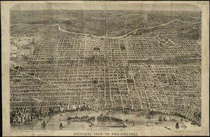
Bird's eye view of Philadelphia
1442.
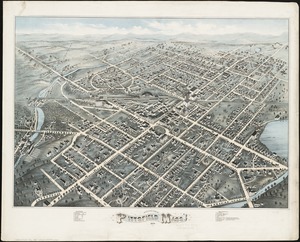
Bird's eye view of Pittsfield, Mass : 1876
1443.
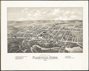
Bird's eye view of Plainville, Conn : 1878
1444.
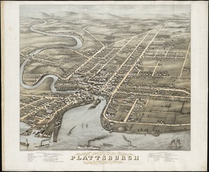
Bird's eye view of Plattsburgh, Clinton Co., New York 1877
1445.
Bird's eye view of Port Townsend, Puget Sound, Washington Territory : from the north-east, 1878
1446.
Bird's eye view of Portsmouth, Rockingham Co., New Hampshire
1447.
Bird's eye view of Rochester, Strafford County, New Hampshire, 1877 : from a position, east of town
1448.
Birds eye view of Syracuse, New York : 1874
1449.
Bird's eye view of the city of Brockton, Plymouth County, Mass : looking southwest, 1882
1450.
Bird's eye view of the city of Holyoke, and village of South Hadley Falls, Mass. looking north
1451.
Bird's eye view of the city of Olympia, East Olympia and Tumwater, Puget Sound, Washington Territory, 1879
1452.
Bird's eye view of the city of Portland, Maine, 1876
1453.
Birds eye view of the Mississippi Valley from Cairo to the Gulf of Mexico
1454.
Birds eye view of the seat of War in Europe
1455.
Birds eye view of the Soudan
1456.
A birds eye view of the Suez Canal
1457.
Bird's eye view of the town of Holbrook : Norfolk County, Mass., looking east, 1882
1458.
Bird's eye view of the town of Nantucket in the State of Massachusetts : looking southwest : 1881
1459.
Bird's eye view of the town of Provincetown, Barnstable County, Mass : 1882
1460.
Birds eye view of the town of Rockland, Plymouth County, Mass : looking northeast
‹ Prev
Next ›
1
2
…
69
70
71
72
73
74
75
76
77
…
437
438