Toggle navigation
LMEC Home
Exhibitions
Georeferencing
Tools for Teachers
Collections
My Favorites
Sign Up / Log In
Search
Search the map portal
Map Collection
Map Collection
Map Sets
Search
Search
Search for
Search In
All Fields
Creator
Title
Subject
Place
Search All Digital Collections
Advanced Search
8357 Results
My Search
Start Over
More Like
commonwealth:3f463689d
Remove constraint More Like: commonwealth:3f463689d
Filter your Search
Place
North and Central America
5,106
United States
3,794
Suffolk (county)
1,216
Boston
1,189
Europe
963
Canada
427
Massachusetts
275
France
269
more
Place
»
Topic
Boston (Mass.)--Maps
740
United States--Maps
270
Real property--Massachusetts--Boston--Maps
222
Landowners--Massachusetts--Boston--Maps
168
Massachusetts--Maps
163
City planning--Massachusetts--Boston--Maps
156
North America--Maps--Early works to 1800
103
New England--Maps
101
more
Topic
»
Date
Date range begin
–
Date range end
Current results range from
1482
to
2023
View distribution
Creator
United States. Hydrographic Office
357
Boston Redevelopment Authority
161
O.H. Bailey & Co
148
Des Barres, Joseph F. W. (Joseph Frederick Wallet), 1722-1824
124
United States. Post Office Dept
120
Ptolemy, 2nd cent
100
Walling, Henry Francis, 1825-1888
94
Bromley, George Washington
86
more
Creator
»
Format
Maps/Atlases
8,298
Manuscripts
215
Prints
51
Books
36
Objects/Artifacts
10
Drawings/Illustrations
8
Posters
4
Georeferenced
Yes
885
No
7,472
Collection
Norman B. Leventhal Map Center Collection
8,191
Boston and New England Maps
2,310
Urban Maps
2,045
Maritime Charts and Atlases
750
American Revolutionary War-Era Maps
638
Boston Redevelopment Authority Collection
192
Massachusetts Real Estate Atlases
38
Mapping Boston Collection
20
more
Collection
»
Available to use
No known restrictions
8,135
Creative Commons license
69
Search Constraints
Sort by date (asc)
relevance
title
date (asc)
date (desc)
Number of results to display per page
20 per page
10
per page
20
per page
50
per page
100
per page
View results as:
grid view
map view
Search Results
7681.
Density of population, 1910
7682.
Density of population, 1920
7683.
A descriptive map of the region within one hundred miles of the capital of the United States : portraying the principal events...
7684.
Electoral vote for President, 1789
7685.
Electoral vote for President, 1792
7686.
Electoral vote for President, 1796
7687.
Kansas-Nebraska Act, May 22, 1854, Vote on passage
7688.
Map showing Japanese-Chinese warfre [sic] now in Shanghai
7689.
Missouri Compromise, March 20, 1820, Vote on striking out provisions restricting slavery
7690.
Outline map of Massachusetts showing boundaries of towns and counties in tidal water
7691.
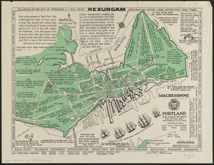
Portland also called Falmouth first settled 1632 chartered as a city 1832
7692.
Presidential and other elections, 1800
7693.
Presidential and other elections, 1804
7694.
Presidential and other elections, 1808
7695.
Presidential and other elections, 1812
7696.
Presidential and other elections, 1816
7697.
Presidential election 1820
7698.
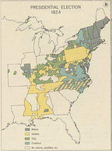
Presidential election 1824
7699.
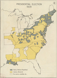
Presidential election 1828
7700.
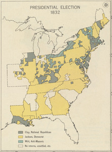
Presidential election 1832
‹ Prev
Next ›
1
2
…
381
382
383
384
385
386
387
388
389
…
417
418


![Map showing Japanese-Chinese warfre [sic] now in Shanghai](https://bpldcassets.blob.core.windows.net/derivatives/images/commonwealth:9s161h819/image_thumbnail_300.jpg)