Toggle navigation
LMEC Home
Exhibitions
Georeferencing
Tools for Teachers
Collections
My Favorites
Sign Up / Log In
Search
Search the map portal
Map Collection
Map Collection
Map Sets
Search
Search
Search for
Search In
All Fields
Creator
Title
Subject
Place
Search All Digital Collections
Advanced Search
726 Results
My Search
Start Over
More Like
commonwealth:2227nh542
Remove constraint More Like: commonwealth:2227nh542
Filter your Search
Place
North and Central America
724
United States
723
Massachusetts
296
Maine
128
Worcester (county)
108
Middlesex (county)
77
Franklin (county)
61
Berkshire (county)
59
more
Place
»
Date
Date range begin
–
Date range end
Current results range from
1786
to
1898
1786 : 1899
1786
1899
1790
1800
1810
1820
1830
1840
1850
1860
1870
1880
1890
Creator
Hales, John Groves
44
Anderson, Philander, 1810?-1853
10
Barber, Luke
10
Darling, E. S.
8
Ballard, Ephraim
7
Carleton, Osgood, 1742-1816
7
Fairchild, David
6
Leonard, Levi
6
more
Creator
»
Format
Maps/Atlases
726
Georeferenced
No
726
Collection
Town plans, 1794
402
Town plans, 1830
324
Available to use
No known restrictions
726
Search Constraints
Sort by relevance
relevance
title
date (asc)
date (desc)
Number of results to display per page
20 per page
10
per page
20
per page
50
per page
100
per page
View results as:
grid view
map view
Search Results
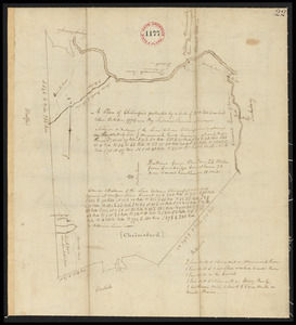
721.
Two plans of Amherst, surveyor's name not given, dated 1794-5.
722.
Two plans of Amherst, surveyor's name not given, dated 1794-5.
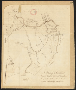
723.
Two plans of Chelmsford made by Fred French, dated November, 1794.
724.
Two plans of Chelmsford made by Fred French, dated November, 1794.
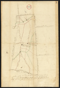
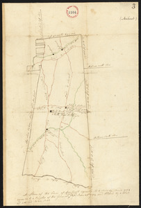
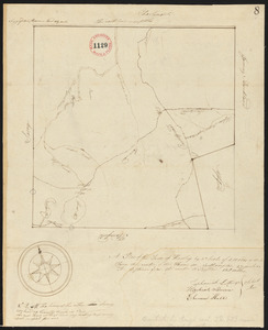
725.
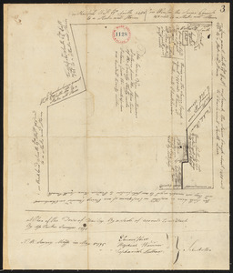
Two plans of Hawley, surveyor's name not given, dated May, 1795.
726.
Two plans of Hawley, surveyor's name not given, dated May, 1795.
+
-
Redo search here
Search when I move the map
Leaflet
| ©
OpenStreetMap
contributors, ©
CartoDB
‹ Prev
Next ›
1
2
…
33
34
35
36
37