Toggle navigation
LMEC Home
Exhibitions
Georeferencing
Tools for Teachers
Collections
My Favorites
Sign Up / Log In
Search
Search the map portal
Map Collection
Map Collection
Map Sets
Search
Search
Search for
Search In
All Fields
Creator
Title
Subject
Place
Search All Digital Collections
Advanced Search
8923 Results
My Search
Start Over
More Like
commonwealth:1257bq69n
Remove constraint More Like: commonwealth:1257bq69n
Filter your Search
Place
North and Central America
6,154
United States
5,070
Massachusetts
2,138
Europe
1,396
Suffolk (county)
1,269
Boston
1,242
Canada
449
Asia
438
more
Place
»
Topic
Boston (Mass.)--Maps
753
United States--Maps
282
Real property--Massachusetts--Boston--Maps
254
City planning--Massachusetts--Boston--Maps
189
Landowners--Massachusetts--Boston--Maps
170
Massachusetts--Maps
166
New England--Maps
104
North America--Maps--Early works to 1800
103
more
Topic
»
Date
Date range begin
–
Date range end
Current results range from
1482
to
2023
View distribution
Creator
United States. Hydrographic Office
595
Boston Redevelopment Authority
192
O.H. Bailey & Co
148
Des Barres, Joseph F. W. (Joseph Frederick Wallet), 1722-1824
124
United States. Post Office Dept
120
Ptolemy, 2nd cent
100
Walling, Henry Francis, 1825-1888
94
Geological Survey (U.S.)
87
more
Creator
»
Format
Maps/Atlases
8,863
Manuscripts
215
Prints
56
Books
36
Objects/Artifacts
10
Drawings/Illustrations
8
Posters
5
Georeferenced
Yes
885
No
8,038
Collection
Norman B. Leventhal Map & Education Center Collection
8,725
Boston and New England Maps
2,393
Urban Maps
2,177
Maritime Charts and Atlases
1,083
American Revolutionary War-Era Maps
638
Boston Redevelopment Authority Collection
225
Massachusetts Real Estate Atlases
38
Mapping Boston Collection
20
more
Collection
»
Available to use
No known restrictions
8,700
Creative Commons license
70
Search Constraints
Sort by relevance
relevance
title
date (asc)
date (desc)
Number of results to display per page
20 per page
10
per page
20
per page
50
per page
100
per page
View results as:
grid view
map view
Search Results
541.
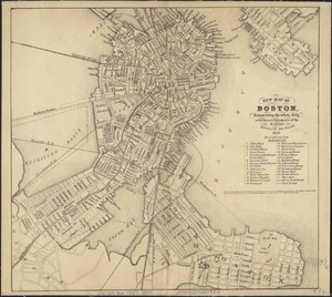
A new & complete map of the city of Boston, with part of Charlestown, Cambridge & Roxbury
542.
A new & complete map of the city of Boston, with part of Charlestown, Cambridge & Roxbury
543.
A new & complete map of the city of Boston, with part of Charlestown, Cambridge, Brookline, Dorchester &c
544.
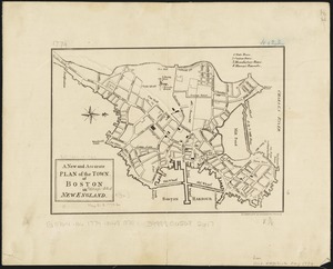
A new and accurate plan of the town of Boston in New England
545.
New Boston and Charles River Bay
546.
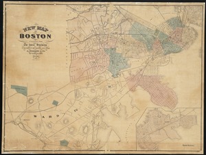
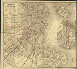
New map of Boston
547.
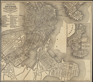
New map of Boston, comprising the whole city, with the new boundaries of the wards
548.
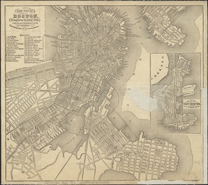
New map of Boston, comprising the whole city, with the new boundaries of the wards
549.
New map of Boston, comprising the whole city, with the new boundaries of the wards
550.
New map of Boston, comprising the whole city, with the new boundaries of the wards
551.
New map of Boston, comprising the whole city, with the new boundaries of the wards
552.
New map of Boston, comprising the whole city, with the new boundaries of the wards
553.
New map of Boston, comprising the whole city, with the new boundaries of the wards
554.
New map of Boston, comprising the whole city, with the new boundaries of the wards
555.
New map of Boston, comprising the whole city, with the new boundaries of the wards
556.
New map of Boston, comprising the whole city, with the new boundaries of the wards
557.
New map of Boston, comprising the whole city, with the new boundaries of the wards
558.
New map of Boston, comprising the whole city, with the new boundaries of the wards
559.
New map of Boston, comprising the whole city, with the new boundaries of the wards
560.
New map of Boston, comprising the whole city, with the new boundaries of the wards
‹ Prev
Next ›
1
2
…
24
25
26
27
28
29
30
31
32
…
446
447