Toggle navigation
LMEC Home
Exhibitions
Georeferencing
Tools for Teachers
Collections
My Favorites
Sign Up / Log In
Search
Search the map portal
Map Collection
Map Collection
Map Sets
Search
Search
Search for
Search In
All Fields
Creator
Title
Subject
Place
Search All Digital Collections
Advanced Search
8773 Results
My Search
Start Over
More Like
commonwealth:0r96fp094
Remove constraint More Like: commonwealth:0r96fp094
Filter your Search
Place
North and Central America
6,004
United States
4,908
Massachusetts
2,152
Europe
1,396
Suffolk (county)
1,047
Boston
1,020
Canada
450
Asia
438
more
Place
»
Topic
Boston (Mass.)--Maps
590
United States--Maps
282
Massachusetts--Maps
235
Real property--Massachusetts--Boston--Maps
175
Landowners--Massachusetts--Boston--Maps
133
New England--Maps
104
North America--Maps--Early works to 1800
103
Europe--Maps
79
more
Topic
»
Date
Date range begin
–
Date range end
Current results range from
1482
to
2023
View distribution
Creator
United States. Hydrographic Office
595
O.H. Bailey & Co
148
Des Barres, Joseph F. W. (Joseph Frederick Wallet), 1722-1824
123
United States. Post Office Dept
120
Ptolemy, 2nd cent
100
Walling, Henry Francis, 1825-1888
95
Geological Survey (U.S.)
92
Jefferys, Thomas, -1771
85
more
Creator
»
Format
Maps/Atlases
8,712
Manuscripts
217
Prints
56
Books
36
Objects/Artifacts
10
Drawings/Illustrations
8
Posters
5
Ephemera
1
Georeferenced
Yes
879
No
7,894
Collection
Norman B. Leventhal Map & Education Center Collection
8,737
Boston and New England Maps
2,279
Urban Maps
2,024
Maritime Charts and Atlases
1,083
American Revolutionary War-Era Maps
639
Boston Redevelopment Authority Collection
90
Applied Geographics, Inc. Records
20
David Judkins Weaver Papers
18
more
Collection
»
Available to use
No known restrictions
8,595
Creative Commons license
51
Search Constraints
Sort by relevance
relevance
title
date (asc)
date (desc)
Number of results to display per page
20 per page
10
per page
20
per page
50
per page
100
per page
View results as:
grid view
map view
Search Results
2441.
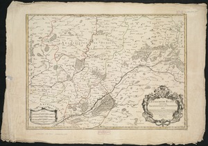
L'Evesché de Blois, dìvìsé en archìdìaconéz et doyennéz
2442.
L'Evesché de Blois, divisé en Archidiaconéz et Doyennéz
2443.
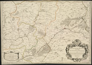
L'Evesché de Chartres dìvìsee en archìdìaconéz et doyennéz
2444.
Evesché de La Rochelle
2445.
Evesché de Laon, ou sont les Duché, et Pairrie de Laon, Balliages de Laon, et Ribemont, Eslections de Laon, et de Guise etc
2446.
Evesché de Luçon : dedié a Monseigneur ... Henry de Barrillon Evesque et Baron de Luçon etc
2447.
Evesché du Puy Le Velay l'un des vingt deux dioceses du Languedoc
2448.
Evropa
2449.
An exact chart of the river St. Laurence, from Fort Frontenac to the island of Anticosti shewing the soundings, rocks, shoals...
2450.
An exact chart of the river St. Laurence, from Fort Frontenac to the island of Anticosti shewing the soundings, rocks, shoals...
2451.
An exact draught of Bostone harbour with a survey of most of the islands about it
2452.
An exact draught of the gulf of Darien & the coast to Porto Bello with Panama in the south sea & the Scotch settlement in...
2453.
Exact plan of General Gage's lines on Boston Neck in America
2454.
An exact plan of the sea coast of the continent from Paucatuck River eastwards to Point Judith and from thence northwards to...
2455.
Exacta & accurata delineatio cùm orarum maritimarum tùm etjam locorum terrestrium qvæ in regionibus China, Cauchinchina,...
2456.
Exactissima Helvetiae, Rhaetiae, Valesiae caeterorumque Confoederatorum ut et finitimorum populorum regionum tabula :...
2457.
Exactissima Palatinatus Rheni ac Ducatus Bipontini tabula, qua tam omnes eorundem Balliviatus subjacentes, quam aliae ditiones...
2458.
Exactissima Regni Scotiae tabula tam in septentrionalem et meriodionalem quam in minores earundem provincias, insulasq[ue] ei...
2459.
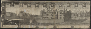
Exequiæ serenissimi ac potentiss. principis ac dni. domini Caroli Gustavi Suecorum Gothorum et Wandalorum regis d. 3 Novemb....
2460.
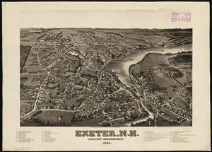
Exeter, N.H : county seat of Rockingham County, 1884
‹ Prev
Next ›
1
2
…
119
120
121
122
123
124
125
126
127
…
438
439


![Exactissima Regni Scotiae tabula tam in septentrionalem et meriodionalem quam in minores earundem provincias, insulasq[ue] ei undique praetensas accurate divisa](https://bpldcassets.blob.core.windows.net/derivatives/images/commonwealth:cj82kz35d/image_thumbnail_300.jpg)