Toggle navigation
LMEC Home
Exhibitions
Georeferencing
Tools for Teachers
Collections
My Favorites
Sign Up / Log In
Search
Search the map portal
Map Collection
Map Collection
Map Sets
Search
Search
Search for
Search In
All Fields
Creator
Title
Subject
Place
Search All Digital Collections
Advanced Search
5 Results
My Search
Start Over
More Like
commonwealth:6t053s73b
Remove constraint More Like: commonwealth:6t053s73b
Creator
United States. Post Office Dept
Remove constraint Creator: United States. Post Office Dept
Topic
Louisiana--Maps
Remove constraint Topic: Louisiana--Maps
Filter your Search
Place
Louisiana
5
North and Central America
5
United States
5
Topic
Counties--Louisiana--Maps
5
Louisiana--Maps
[remove]
5
Postal service--Louisiana--Maps
5
Railroads--Louisiana--Maps
5
Date
Date range begin
–
Date range end
Current results range from
1883
to
1903
1883 : 1904
1883
1904
View distribution
Creator
United States. Post Office Dept
[remove]
5
Format
Maps/Atlases
5
Georeferenced
Yes
4
No
1
Collection
Norman B. Leventhal Map & Education Center Collection
5
Available to use
No known restrictions
5
Search Constraints
Sort by relevance
relevance
title
date (asc)
date (desc)
Number of results to display per page
20 per page
10
per page
20
per page
50
per page
100
per page
View results as:
grid view
map view
Search Results
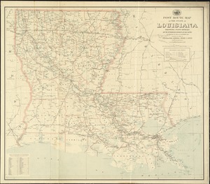
1.
Post route map of the state of Louisiana showing post offices and the intermediate distances on mail routes in operation on the...
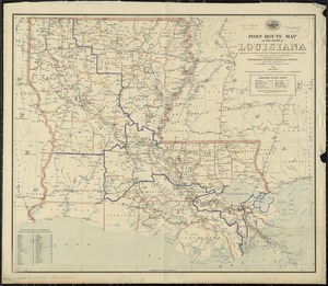
2.
Post route map of the State of Louisiana showing post offices with the intermediate distances and mail routes in operation on...
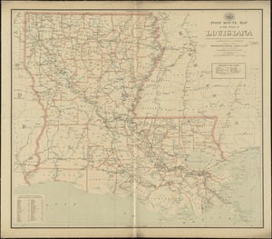
3.
Post route map of the state of Louisiana showing post offices with the intermediate distances on mail routes in operation on...
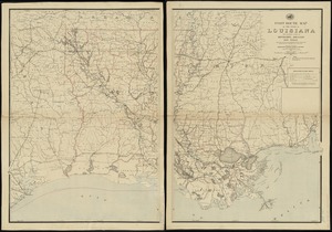
4.
Post route map of the state of Louisiana with adjacent parts of Mississippi, Arkansas, and Texas : showing post offices, with...
5.
Post route map of the State of Louisiana with adjacent parts of Mississippi, Arkansas, and Texas showing post offices with the...