Toggle navigation
LMEC Home
Exhibitions
Georeferencing
Tools for Teachers
Collections
My Favorites
Sign Up / Log In
Search
Search the map portal
Map Collection
Map Collection
Map Sets
Search
Search
Search for
Search In
All Fields
Creator
Title
Subject
Place
Search All Digital Collections
Advanced Search
3 Results
My Search
Start Over
More Like
commonwealth:d504vk225
Remove constraint More Like: commonwealth:d504vk225
Creator
Gale, Samuel, 1747-1826
Remove constraint Creator: Gale, Samuel, 1747-1826
Filter your Search
Place
Canada
3
Quebec
3
North and Central America
1
Richelieu River
1
United States
1
Topic
Seigneuries--Québec (Province)--Maps
3
Townships--Québec (Province)--Maps
3
Canada--Boundaries--United States
2
Québec (Province)--Maps--Early works to 1800
2
Québec (Province)--Maps
1
Richelieu River (N.Y. and Vt.-Québec)--Maps
1
Date
Date range begin
–
Date range end
Current results range from
1794
to
1796
1794 : 1797
1794
1797
View distribution
Creator
Gale, Samuel, 1747-1826
[remove]
3
Duberger, Jean-Baptiste, 1767-1821
2
Format
Maps/Atlases
3
Georeferenced
No
3
Collection
American Revolutionary War-Era Maps
3
Library and Archives Canada Collection
3
Search Constraints
Sort by relevance
relevance
title
date (asc)
date (desc)
Number of results to display per page
20 per page
10
per page
20
per page
50
per page
100
per page
View results as:
grid view
map view
Search Results
1.
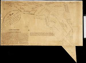
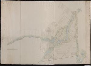
By order of His Excellency Guy Lord Dorchester... plan of part of the province of Lower Canada containing the country from the...
2.
A plan of that part of the province of Lower Canada, lying between the rivers Saint Lawrence, Richelieu & the province line
3.
Plan of the west part of the province of Lower Canada from the R.r Sorel upwards, as far as any survey's hitherto been made