Toggle navigation
LMEC Home
Exhibitions
Georeferencing
Tools for Teachers
Collections
My Favorites
Sign Up / Log In
Search
Search the map portal
Map Collection
Map Collection
Map Sets
Search
Search
Search for
Search In
All Fields
Creator
Title
Subject
Place
Search All Digital Collections
Advanced Search
6 Results
My Search
Start Over
More Like
commonwealth:2227nh207
Remove constraint More Like: commonwealth:2227nh207
Creator
Carleton, Osgood, 1742-1816
Remove constraint Creator: Carleton, Osgood, 1742-1816
Filter your Search
Place
North and Central America
6
United States
6
Maine
5
Hancock (county)
2
Androscoggin (county)
1
Boston
1
Bucksport
1
Garland
1
more
Place
»
Date
Date range begin
–
Date range end
Current results range from
1787
to
1795
1787 : 1796
1787
1796
View distribution
Creator
Carleton, Osgood, 1742-1816
[remove]
6
Format
Maps/Atlases
6
Georeferenced
No
6
Collection
Town plans, 1794
6
Available to use
No known restrictions
6
Search Constraints
Sort by relevance
relevance
title
date (asc)
date (desc)
Number of results to display per page
20 per page
10
per page
20
per page
50
per page
100
per page
View results as:
grid view
map view
Search Results
1.
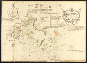
Plan of Boston surveyed by Osgood Carleton, dated 1795.
2.
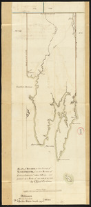
Plan of Bucksport, surveyed by Osgood Carleton, dated 1787.
3.
Plan of Poland (Bakerstown) surveyed by Osgood Carleton, dated 1792.
4.
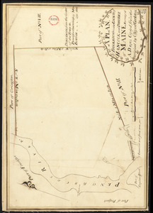
Plan of Steuben surveyed by Osgood Carleton, dated 1794-5.
5.
Plan of Township No. 2 (Orland) east of the Penobscot River surveyed by Osgood Carleton, dated 1795.
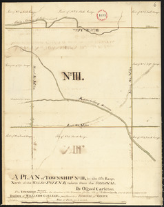
6.
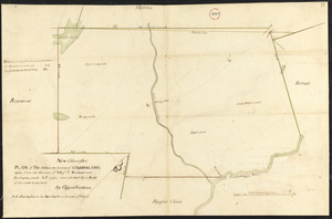
Plan surveyed by Osgood Carleton of Township No. 3 (Garland), granted Williams College, dated 1794-5.