Toggle navigation
LMEC Home
Exhibitions
Georeferencing
Tools for Teachers
Collections
My Favorites
Sign Up / Log In
Search
Search the map portal
Map Collection
Map Collection
Map Sets
Search
Search
Search for
Search In
All Fields
Creator
Title
Subject
Place
Search All Digital Collections
Advanced Search
7 Results
My Search
Start Over
More Like
commonwealth:25152m82r
Remove constraint More Like: commonwealth:25152m82r
Creator
Ballard, Ephraim
Remove constraint Creator: Ballard, Ephraim
Filter your Search
Place
Maine
7
North and Central America
7
United States
7
Kennebec (county)
5
Bowdoinham
1
Franklin (county)
1
Gardiner
1
Hallowell
1
more
Place
»
Date
Date range begin
–
Date range end
Current results range from
1794
to
1795
1794 : 1796
1794
1796
View distribution
Creator
Ballard, Ephraim
[remove]
7
Moore Sylvester
4
Moore, Sylvester J.
1
Format
Maps/Atlases
7
Georeferenced
No
7
Collection
Town plans, 1794
7
Available to use
No known restrictions
7
Search Constraints
Sort by relevance
relevance
title
date (asc)
date (desc)
Number of results to display per page
20 per page
10
per page
20
per page
50
per page
100
per page
View results as:
grid view
map view
Search Results
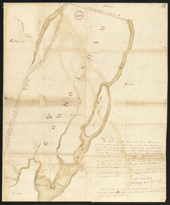
1.
Plan of Bowdoinham made by Ephraim Ballard and Sylverster J. Moore, dated April, 1795.
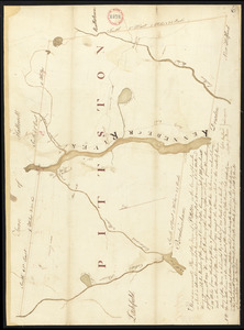
2.
Plan of Gardiner and Pittston made by Ephraim Ballard and Sylvester Moore, dated April, 1795.
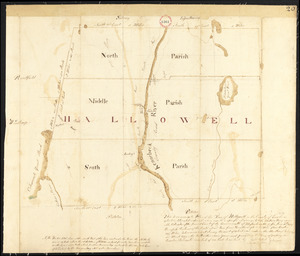
3.
Plan of Hallowell surveyed by Ephraim Ballard and Sylvester Moore, dated March, 1795.
4.
Plan of New Sharon surveyed by Ephraim Ballard, dated 1794-5.
5.
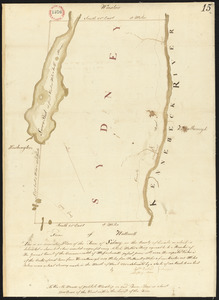
Plan of Sidney surveyed by Sylvester Moore and Ephraim Ballard, dated March 1795.
6.
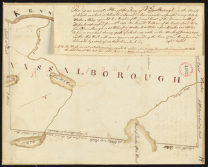
Plan of Vassalborough surveyed by Ephraim Ballard, dated January, 1795.
7.
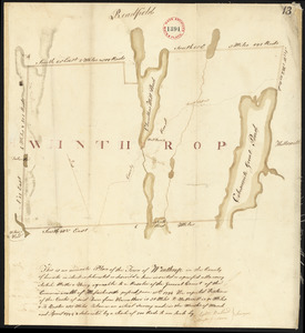
Plan of Winthrop (Pondtown) surveyed by Ephraim Ballard and Sylvester Moore, dated April, 1795.