Toggle navigation
LMEC Home
Exhibitions
Georeferencing
Tools for Teachers
Collections
My Favorites
Sign Up / Log In
Search
Search the map portal
Map Collection
Map Collection
Map Sets
Search
Search
Search for
Search In
All Fields
Creator
Title
Subject
Place
Search All Digital Collections
Advanced Search
4 Results
My Search
Start Over
More Like
commonwealth:6d570f98k
Remove constraint More Like: commonwealth:6d570f98k
Creator
Bache, A. D. (Alexander Dallas), 1806-1867
Remove constraint Creator: Bache, A. D. (Alexander Dallas), 1806-1867
Filter your Search
Place
North and Central America
4
United States
4
New England
2
Charleston (county)
1
Charleston Harbor
1
South Carolina
1
Topic
Coastlines
4
Harbors
1
Navigation
1
Date
Date range begin
–
Date range end
Current results range from
1854
to
1866
1854 : 1867
1854
1867
View distribution
Creator
Bache, A. D. (Alexander Dallas), 1806-1867
[remove]
4
Ackerman, James, 1815 or 1816-1864
1
United States Coast Survey
1
Format
Maps/Atlases
4
Georeferenced
No
4
Collection
Ralph Finos Map Collection at Phillips Academy
4
Available to use
No known restrictions
4
Search Constraints
Sort by relevance
relevance
title
date (asc)
date (desc)
Number of results to display per page
20 per page
10
per page
20
per page
50
per page
100
per page
View results as:
grid view
map view
Search Results
1.
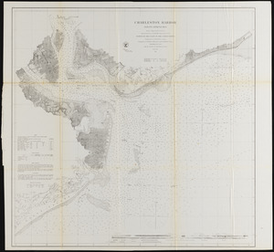
Charleston Harbor and its approaches
2.
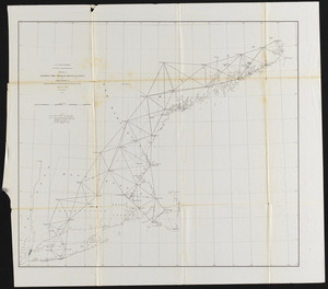
Sketch A, showing the primary triangulation in section I and the connection of the baselines in sections I and II
3.
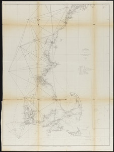
Sketch A showing the progress of the survey in Section No. 1 from 1844 to 1854
4.
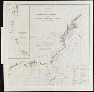
Sketch showing the progress of the survey on the Atlantic, Gulf of Mexico, and Pacific coast of the United States