Toggle navigation
LMEC Home
Exhibitions
Georeferencing
Tools for Teachers
Collections
My Favorites
Sign Up / Log In
Search
Search the map portal
Map Collection
Map Collection
Map Sets
Search
Search
Search for
Search In
All Fields
Creator
Title
Subject
Place
Search All Digital Collections
Advanced Search
1 Results
My Search
Start Over
More Like
commonwealth:3f4638924
Remove constraint More Like: commonwealth:3f4638924
Collection
William L. Clements Library Collection
Remove constraint Collection: William L. Clements Library Collection
Filter your Search
Place
Eastern United States
1
North and Central America
1
United States
1
Topic
Atlantic Coast (North America)--Maps
1
Military trophies--Pictorial works
1
United States--History--Revolution, 1775-1783--Maps
1
Date
1776
1
Creator
Berndt, Johann Christian, 1748-1812
1
Jaeger, Johann Christian
1
Format
Maps/Atlases
1
Georeferenced
No
1
Collection
American Revolutionary War-Era Maps
1
William L. Clements Library Collection
[remove]
1
Search Constraints
Sort by relevance
relevance
title
date (asc)
date (desc)
Number of results to display per page
20 per page
10
per page
20
per page
50
per page
100
per page
View results as:
grid view
map view
Search Results
1.
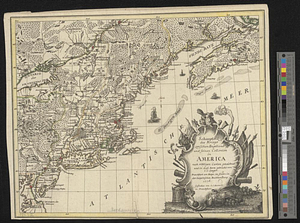
Schauplatz des kriegs zwischen Engelland und seinen collonien in America nach richtigen carten gezeichnet und in diese form...
+
-
Redo search here
Search when I move the map
Leaflet
| ©
OpenStreetMap
contributors, ©
CartoDB