Toggle navigation
LMEC Home
Exhibitions
Georeferencing
Tools for Teachers
Collections
My Favorites
Sign Up / Log In
Search
Search the map portal
Map Collection
Map Collection
Map Sets
Search
Search
Search for
Search In
All Fields
Creator
Title
Subject
Place
Search All Digital Collections
Advanced Search
13680 Results
Filter your Search
Place
North and Central America
10,344
United States
8,475
Massachusetts
2,789
Suffolk (county)
1,677
Boston
1,633
Europe
1,415
Canada
950
New York
649
more
Place
»
Topic
Boston (Mass.)--Maps
747
City planning--Massachusetts--Boston--Maps
418
United States--History--Revolution, 1775-1783--Maps
329
United States--Maps
322
Real property--Massachusetts--Boston--Maps
254
Urban renewal--Massachusetts--Boston--Maps
254
Massachusetts--Maps
231
Insurance surveys
197
more
Topic
»
Date
Date range begin
–
Date range end
Current results range from
1482
to
2023
View distribution
Creator
United States. Hydrographic Office
597
Boston Redevelopment Authority
404
Des Barres, Joseph F. W. (Joseph Frederick Wallet), 1722-1824
247
Royal United Services Institute for Defence and Security Studies
160
Jefferys, Thomas, -1771
154
George, III, King of Great Britain, 1738-1820
152
George, IV, King of Great Britain, 1762-1830
151
O.H. Bailey & Co
148
more
Creator
»
Format
Maps/Atlases
13,499
Manuscripts
985
Prints
102
Books
49
Drawings/Illustrations
44
Photographs
15
Objects/Artifacts
13
Documents
7
more
Format
»
Georeferenced
Yes
979
No
12,701
Collection
Norman B. Leventhal Map & Education Center Collection
9,096
American Revolutionary War-Era Maps
3,305
Boston and New England Maps
2,915
Urban Maps
2,471
Maritime Charts and Atlases
1,169
William L. Clements Library Collection
910
Library of Congress Collection
618
Boston Redevelopment Authority Collection
475
more
Collection
»
Available to use
No known restrictions
10,246
Creative Commons license
1,678
Search Constraints
Sort by relevance
relevance
title
date (asc)
date (desc)
Number of results to display per page
20 per page
10
per page
20
per page
50
per page
100
per page
View results as:
grid view
map view
Search Results
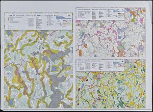
12801.
Town of Sherborn protected open space and land use
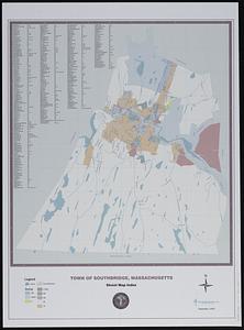
12802.
Town of Southbridge, Massachusetts : street map index
12803.
Town of Three Rivers
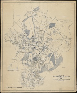
12804.
Town of Wakefield, Mass.
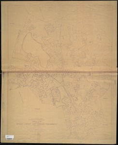
12805.
Town of Wakefield Mass. stormwater drainage report : general plan showing street layout and surface topography
12806.
The town of Winchester, Massachusetts
12807.
Town plan for the town of Wakefield, Mass.
12808.
Townsend Center, Mass
12809.
Townsend's Patent folding globe
12810.
Township map of Bureau, Putnam, Stark, Marshall, Peoria, and Woodford Counties
12811.
Township map of Christian, Moultry, Shelby, Fayette, and Effingham Counties
12812.
Township map of Clay, Richland, Lawrence Wabash Edwards, and Wayne Counties
12813.
Township map of Clinton, Marion, Washington, and Jefferson Counties
12814.
Township map of Douglas, Edgar, Coles, Cumberland Clark, Jasper, and Crawford Counties
12815.
Township map of Greene, Jersey, Macoupin, Montgomery, and Bond Counties
12816.
Township map of Hamilton, White, Gallatin, Saline, and Hardin, Counties
12817.
Township map of Hancock, McDonough, Schuyler, Adams and Brown, Counties
12818.
Township map of La Salle, Grundy, and Livingston Counties
12819.
Township map of Randolph, Perry, Franklin, Jackson, and Williamson Counties
12820.
Township map of Rock Island, Henry, and Mercer Counties
‹ Prev
Next ›
1
2
…
637
638
639
640
641
642
643
644
645
…
683
684