Toggle navigation
LMEC Home
Exhibitions
Georeferencing
Tools for Teachers
Collections
My Favorites
Sign Up / Log In
Search
Search the map portal
Map Collection
Map Collection
Map Sets
Search
Search
Search for
Search In
All Fields
Creator
Title
Subject
Place
Search All Digital Collections
Advanced Search
4128 Results
My Search
Start Over
Date Range
before 1800
Remove constraint Date Range: before 1800
All Fields
americas
Remove constraint All Fields: americas
Filter your Search
Place
North and Central America
3,718
United States
2,492
Canada
642
Massachusetts
471
New York
376
North America
307
South America
204
Maine
203
more
Place
»
Topic
United States--History--Revolution, 1775-1783--Maps
321
North America--Maps--Early works to 1800
179
United States--History--French and Indian War, 1754-1763--Maps
161
Manuscript maps--Early works to 1800
121
New England--Maps--Early works to 1800
89
America--Maps--Early works to 1800
73
United States--Maps--Early works to 1800
59
Western Hemisphere--Maps--Early works to 1800
59
more
Topic
»
Date
Date range begin
–
Date range end
Current results range from
1507
to
1899
View distribution
Creator
Des Barres, Joseph F. W. (Joseph Frederick Wallet), 1722-1824
196
Jefferys, Thomas, -1771
149
George, III, King of Great Britain, 1738-1820
146
George, IV, King of Great Britain, 1762-1830
145
Royal United Services Institute for Defence and Security Studies
137
Amherst, Jeffery Amherst, Baron, 1717-1797
110
Sayer, Robert, 1725-1794
99
Faden, William, 1749-1836
93
more
Creator
»
Format
Maps/Atlases
4,046
Manuscripts
739
Drawings/Illustrations
36
Prints
34
Books
8
Objects/Artifacts
3
Documents
1
Ephemera
1
Georeferenced
Yes
113
No
4,015
Collection
American Revolutionary War-Era Maps
3,095
Norman B. Leventhal Map & Education Center Collection
1,166
William L. Clements Library Collection
887
Library of Congress Collection
552
Town plans, 1794
401
British Library Collection
346
Maritime Charts and Atlases
331
Richard H. Brown Revolutionary War Map Collection at Mount Vernon
274
more
Collection
»
Available to use
No known restrictions
1,525
Creative Commons license
1,430
Search Constraints
Sort by relevance
relevance
title
date (asc)
date (desc)
Number of results to display per page
20 per page
10
per page
20
per page
50
per page
100
per page
View results as:
grid view
map view
Search Results
4101.
Gaspee Bay
4102.
Hare Island; Pointe aux Allouettes of Larks Point; English Bank
4103.
Manicouagan Shoals; Havre St. Nicholas; Bay of the Seven Islands
4104.
Part of the Anticosti Island; Mingan Island; Mignan Harbor
4105.
Plan of the road and river between Niagara and fort Schlosser with the different posts erected on the communication, by order...
4106.
Region of Gaspee Bay
4107.
Region of Hare Island
4108.
The River St. Lawrence from Mal Bay to the Basin of Quebec
4109.
The River St. Lawrence from the Basin of Quebec to the Falls of Richeu
4110.
The Seven Islands and the Bay
4111.
The Shoals of Beauport; The River St. Lawrence from the Basin of Quebec to the Falls of Richeu
4112.
St. Paul's Bay; Isle de Coudres; Great Cove; Pt. de Mille Vaches
4113.
Grund riss de Americanischen insuln Cape Breton, St. Iean und Anticosti im Flusse S. Laurencii
4114.
PLAN of the COUNTRY from FORT EDWARD to CROWN POINT
4115.
Town of Three Rivers
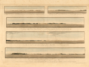
4116.
The Wolves, a cluster of isles lying s.e. near 3 leagues from Pasamaquady Bay ... ; Grand Manan Island ... ; A view of the...
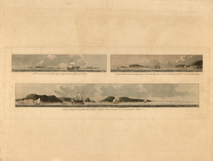
4117.
The Wolves, (a cluster of isles) lying s.e. off the entrance of Passamaquadi Bay ; Grand Manan Island ... ; View of the shore...
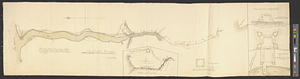
4118.
Hudson River from Stony Point to West Point
4119.
Sketch of the country from Fort Du Quesne to Niagara as described by an intelligent Indian who had resided there for a...
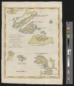
4120.
The Dutch islands of St. Eustatia, Saba, and St. Martins; the French island of St. Bartholomew; the English islands of St....
‹ Prev
Next ›
1
2
…
202
203
204
205
206
207