L'Afrique, colle tracce degli antichi e recenti viaggi si marittimi che terrestri degli Europei in essa
Item Information
- Title:
- L'Afrique, colle tracce degli antichi e recenti viaggi si marittimi che terrestri degli Europei in essa
- Description:
-
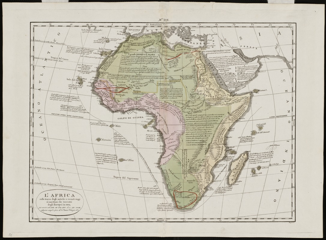
This fascinating map of Africa comes from a revised Italian edition of Le Sage's "Atlas Historique", first published in London in 1802. This atlas was also published for several decades in foreign editions, one of which was Italian, by Girolamo Tasso in 1830. The map includes historical comments about early European exploration of Africa, with mention of the 15th-century Portuguese voyages to the Canary and Cape Verde Islands and along the west coast of the continent. There are also comments about the voyages of Vasco de Gama in 1497 and 1498 around the Cape of Good Hope and Marco Polo's voyage to Madagascar. Shown in red are the inland routes taken by 18th century explorers such as Frederick Horneman (from Cairo in 1798), Mungo Park (Gambia in 1795), and Francois le Vaillant (South Africa in 1781). Le Sage, whose real name was Emmanuel Marie Joseph Auguste Dieudonné, Comte de Las Cases, took on the pseudonym Le Sage, because, in his words, he wanted to preserve his family's name and honor from desecration by would-be critics of the Atlas. He accompanied Napoleon during his imprisonment on the island of St. Helena from 1815 to 1821, and later published the former Emperor's memoirs under his given name. It is not a coincidence that this map points out and describes the island of St. Helena in the southern part of the Gulf of Guinea, and describes Napoleon's imprisonment there.
- Creator:
- Las Cases, Emmanuel-Auguste-Dieudonné, comte de, 1766-1842
- Name on Item:
-
por servire all' Atl. St. Pollet di A. Le-Sage, edizione ampl. e pros. di G. Tasso.
- Date:
-
1830
- Format:
-
Maps/Atlases
- Location:
-
Boston Public Library
Norman B. Leventhal Map & Education Center - Collection (local):
-
Norman B. Leventhal Map & Education Center Collection
- Subjects:
-
Africa--Maps
- Places:
-
Africa
Africa
- Extent:
- 1 map : col. ; 36 x 46 cm.
- Terms of Use:
-
No known copyright restrictions.
No known restrictions on use.
- Publisher:
-
Venice :
[Pasquali Inc.]
- Scale:
-
Scale not given.
- Language:
-
Italian
- Notes:
-
Relief shown pictorially.
Appears in Le Sage's Atlas Historique.
Exhibited in “Faces and Places,” at the Boston Public Library, Boston, MA, October 2003 - September 2004. MB (BRL)
- Identifier:
-
06_01_000066
- Call #:
-
G8200 1830 .L3
- Barcode:
-
39999052507397


