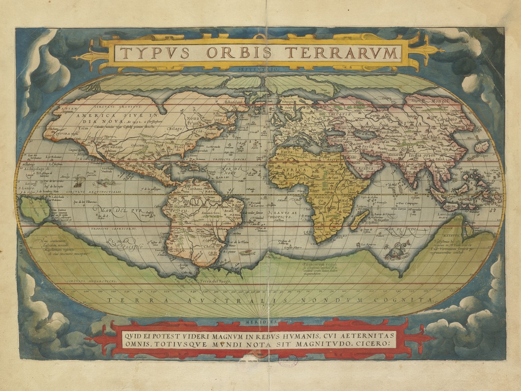
Typus orbis terrarum
Item Information
- Title:
- Typus orbis terrarum
- Title (alt.):
-
Typvs orbis terrarvm
- Description:
-
Ortelius' book of maps, first published in 1570, is considered the first modern world atlas. It was the first time that a set of maps, contemporary to the date of publication, was designed, drawn, and engraved with the intention of publishing them in a bound volume. Ortelius did not refer to his publication as an "atlas," as we know it today. Rather he entitled it "Theater of the World" implying not only that the entire known world could be viewed in this one book, but that the Earth was a stage on which human actions unfolded. Although most of the maps in this book pertain to European countries and provinces, it can be considered a world atlas because it also includes a map of the world (displayed here), as well as one map for each of the four continents. This world map was based on a large 21-sheet world map published by Ortelius' colleague, Gerard Mercator the year before. It displayed almost a century of European exploration in the Americas delineating relatively accurate coast lines in the Equatorial areas, but with greatly distorted shapes in southern South America and northern and western North America. Interestingly, the map prematurely showed a southern polar continent since the southern oceans had not yet been explored. The projected southern continent was based on the reports of Magellan sighting Terra del Fuego when he rounded the tip of South America and the accounts of early Dutch discoveries along the Australian coast. While the first edition of Ortelius' Theatrum Orbis Terrarum was published in Latin in 1570, this map book was subsequently issued in 33 editions over the next 41 years. It was also translated into six other languages -- German, Dutch, French, Spanish, Italian, and English. The success of this first "atlas" publication marked the beginning of the golden age of Flemish and Dutch cartography with cartographers from the Low Countries dominating the map trade until the end of the 17th century.
- Creator:
- Ortelius, Abraham, 1527-1598
- Name on Item:
-
[Abraham Ortelius].
- Date:
-
1570
- Format:
-
Maps/Atlases
- Location:
-
Boston Public Library
Norman B. Leventhal Map & Education Center - Collection (local):
-
Norman B. Leventhal Map & Education Center Collection
- Subjects:
-
World maps--Early works to 1800
- Places:
-
World
- Extent:
- 1 map : col. ; 46 x 64 cm.
- Terms of Use:
-
No known copyright restrictions.
No known restrictions on use.
- Publisher:
-
Antwerp :
A. Ortelius
- Scale:
-
Scale not given.
- Language:
-
Latin
- Notes:
-
Relief shown pictorially.
"Quid ei potest videri magnum in rebus humanis, cui aeternitas omnis, totius que mundi nota sit magmitudo. Cicero."
Appears in the author's Theatrum orbis terrarum. Antverpiae. 1570.
Exhibited in “Journeys of the Imagination,” at the Boston Public Library, Boston, MA, April - August 2006. MB (BRL)
Cataloging, conservation, and digitization made possible in part by The National Endowment for the Humanities: Exploring the human endeavor.
Atlas scanned by Internet Archive http://archive.org/stream/theatrumorbister00orte
- Notes (exhibitions):
-
Exhibited: "Shakespeare’s Here and Everywhere" organized by the Norman B. Leventhal Map Center at the Boston Public Library, 2016-2017.
- Identifier:
-
05_01_000247
- Call #:
-
G1006 .T54 1570
- Barcode:
-
30000002782909


