F. Klemm's map of Baltimore and the proposed extension of the city limits
Item Information
- Title:
- F. Klemm's map of Baltimore and the proposed extension of the city limits
- Description:
-
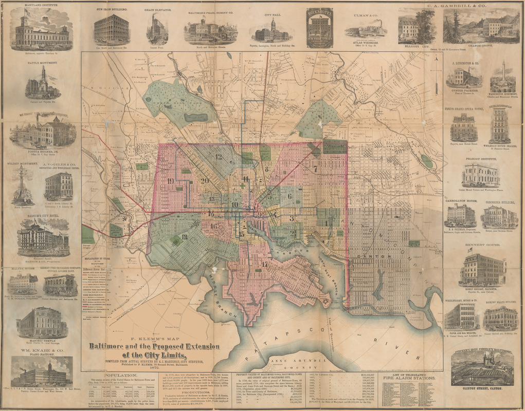
Like many cities in the nineteenth century, Baltimore demonstrated continuous growth, both in terms of population and land. By 1870, the city’s population had grown to over five times the number of people recorded in 1790. To account for this dramatic increase, the city began to expand away from its waterfront, which had been a principal port since the eighteenth century. Unlike most northern cities, Baltimore had a rich agricultural economy in addition to a typical northern manufacturing economy, which made for a uniquely square and more spread out city plan. This map marks the city’s unusually linear limits with a dashed and dotted line that surrounds the colored area, and it also includes the land that Baltimore incorporated into the city in later years. The map utilizes different colors to indicate districts and marks the city’s many parks and cemeteries in a distinctive green. This map also provides information about life in Baltimore in 1872, including property values and taxation, as well as twenty-nine beautiful vignettes depicting the city’s prominent businesses and landmarks. These buildings and monuments include City Hall, Baltimore’s Washington Monument, which predated the one in Washington, D.C., and the Maryland Institute. Also visible across the bottom section of the map is the Baltimore and Ohio Railroad, the first railroad chartered in the United States.
- Cartographer:
- Martenet, Simon J.
- Publisher:
- Klemm, F.
- Name on Item:
-
compiled from actual surveys by S.J. Martenet, city surveyor
- Date:
-
1872
- Format:
-
Maps/Atlases
- Location:
- MacLean Collection Map Library
- Collection (local):
-
MacLean Collection Map Library
- Subjects:
-
Landowners--Maryland--Baltimore--Maps
Baltimore (Md.)--Maps
- Places:
-
Baltimore Independent City (county)Baltimore
- Extent:
- 1 map : color ; 74 cm x 94 cm
- Terms of Use:
-
Public Domain/No known restrictions on use. Contact host institution to download image.
Contact host institution for more information.
- Publisher:
-
Baltimore :
F. Klemm
- Scale:
-
Scale [ca. 1:19,500]
- Language:
-
English
- Notes:
-
Shows wards and some landowners.
Includes illustrations of buildings, list of telegraphic fire alarm stations, text, and population and property statistics.
Lithograph.
- Identifier:
-
MacLeanColl_10435_Baltimore
- Call #:
-
10435