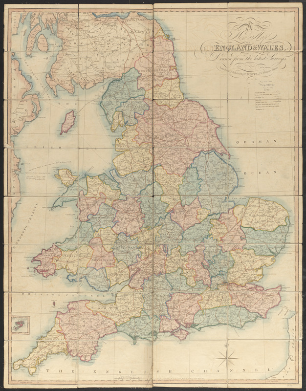
A new map of England & Wales, drawn from the latest surveys
Item Information
- Title:
- A new map of England & Wales, drawn from the latest surveys
- Publisher:
- Bumpus, John
- Date:
-
1826
- Format:
-
Maps/Atlases
- Location:
-
Boston Public Library
Norman B. Leventhal Map & Education Center - Collection (local):
-
Norman B. Leventhal Map & Education Center Collection
- Subjects:
-
Roads--England--Maps
Roads--Wales--Maps
England--Maps
Wales--Maps
- Places:
-
England
Wales
- Extent:
- 1 map : color ; 99 x 76 cm
- Terms of Use:
-
No known copyright restrictions.
No known restrictions on use.
- Publisher:
-
London :
Published by I. Bumpus
- Scale:
-
Scale approximately 1:700,000
- Language:
-
English
- Notes:
-
Also indicates distances on roads between cities.
Inset: The Scilly Islands.
"Printed and published as the act directs Octr. 29th 1826."
- Identifier:
-
06_01_014848
- Call #:
-
G5750 1826 .B86
- Barcode:
-
39999065706127