Map of the Hudson River Rail Road from New York to Albany
Item Information
- Title:
- Map of the Hudson River Rail Road from New York to Albany
- Description:
-
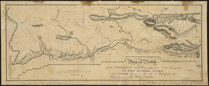
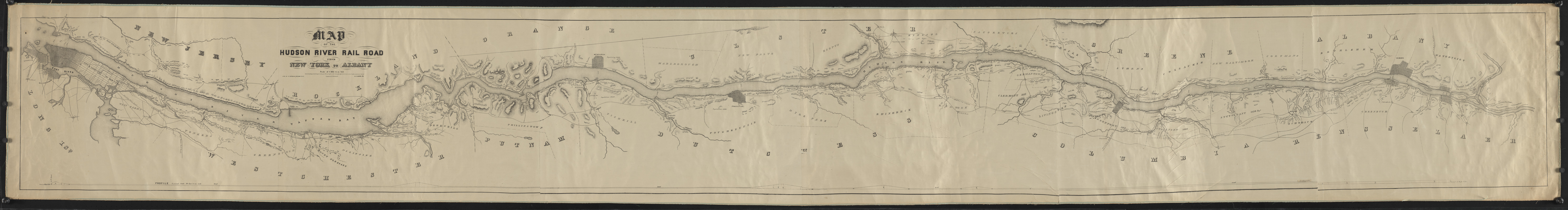
America Transformed: For 18th-century French, British, and American colonists, the Hudson River was strategically important as part of the corridor linking New York City and Montreal. With the completion of the Erie Canal, it became part of the route connecting the Atlantic Ocean to the Great Lakes. This topographic strip map, published in 1848, emphasizes the navigable portion of the river and marks the route of the new Hudson River Railroad, chartered in 1846. The map identified major towns and villages, some of which were becoming industrial centers that manufactured goods for markets in New York City or for export.
- Draftsman:
- Moore, W. C.
- Engraver:
- Haering, Robert
- Lithographer:
- Snyder, George, approximately 1820-
- Name on Item:
-
Lith. of G. Snyder ; engraved by Robt. Haering ; W.C. Moore del.
- Date:
-
(c) 1848
- Format:
-
Maps/Atlases
- Location:
- Private Collection
- Collection (local):
-
Private Collection
- Subjects:
-
Railroads--Hudson River Valley (N.Y. and N.J.)--Maps
Hudson River Valley (N.Y. and N.J.)--Maps
Hudson River Railroad
- Places:
-
Hudson River
- Extent:
- 1 map ; 44 x 383 cm
- Terms of Use:
-
No known copyright restrictions.
No known restrictions on use.
- Publisher:
-
N.Y. :
Lith. of G. Snyder
- Scale:
-
Scale 1:63,360
- Language:
-
English
- Notes:
-
Topographic strip map of the Hudson River Valley from Waterford to New York City, showing drainage, relief by hachures, county and township boundaries, cities and towns, roads and canals. Indicates the track of the Hudson River Railroad and the "line surveyed but not adopted." Chartered in 1846 and consolidated with New York Central Railroad.
Relief shown by hachures.
"Entered according to Act of Congress in the year 1848 by G. Snyder."
Includes vertical profile.
- Notes (citation):
-
LC Railroad maps, 430
- Notes (exhibitions):
-
Exhibited: "America transformed. Part 1: the United States expands westward," organized by the Norman B. Leventhal Map & Education Center at the Boston Public Library, 2019.
- Identifier:
-
06_01_016663