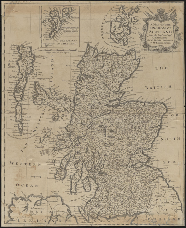
A map of the kingdom of Scotland from the latest and best observations, for Mr. Tindal's Continuation of Mr. Rapin's History
Item Information
- Title:
- A map of the kingdom of Scotland from the latest and best observations, for Mr. Tindal's Continuation of Mr. Rapin's History
- Cartographer:
- Seale, Richard William
- Name on Item:
-
R.W. Seale del. et sculp.
- Date:
-
[1744]
- Format:
-
Maps/Atlases
- Location:
-
Boston Public Library
Norman B. Leventhal Map & Education Center - Collection (local):
-
Norman B. Leventhal Map & Education Center Collection
- Subjects:
-
Scotland--Maps--Early works to 1800
- Places:
-
Scotland
- Extent:
- 1 map ; 48 x 38 cm
- Terms of Use:
-
No known copyright restrictions.
No known restrictions on use.
- Publisher:
-
[London] :
[Printed for John and Paul Knapton]
- Scale:
-
Scale approximately 1:1,380,000
- Language:
-
English
- Notes:
-
Relief shown pictorially.
Features include trees and lochs.
Ornate title cartouche.
Edge of sheet cropped.
Inset: The islands of Shetland.
Map originally included in "The History of England" / by Mr. Rapin de Thoyras, London, volume 3, 1744 and 1751 editions.
Gift: Robin and Kate Davidson; 2018.
- Notes (date):
-
This date is inferred.
- Notes (citation):
-
RSGS and Moir. The early maps of Scotland, volume 1, 1973, page 184
- Identifier:
-
06_01_016637
- Call #:
-
G5770 1744 .S43
- Barcode:
-
39999085949079


![Exactissima Regni Scotiae tabula tam in septentrionalem et meriodionalem quam in minores earundem provincias, insulasq[ue] ei undique praetensas accurate divisa](https://bpldcassets.blob.core.windows.net/derivatives/images/commonwealth:cj82kz35d/image_thumbnail_300.jpg)
