Newsmap : week of December 16 to December 22, 224th week of the war, 106th week of U.S. Participation. Monday, December 27, 1943


Item Information
- Title:
- Newsmap : week of December 16 to December 22, 224th week of the war, 106th week of U.S. Participation. Monday, December 27, 1943
- Title (alt.):
-
Land of the setting sun
- Author:
- United States. Army Service Forces. Morale Service Division
- Cartographer:
- Harrison, Richard Edes
- Distributor:
- United States. Bureau of Naval Personnel. Educational Services Section
- Distributor:
- United States. Army Air Forces. Publications Division
- Name on Item:
-
prepared and distributed by Army Orientation Course, Morale Services Division, Army Service Forces, War Dept.
- Date:
-
1943
- Format:
-
Maps/Atlases
- Location:
-
Boston Public Library
Norman B. Leventhal Map & Education Center - Collection (local):
-
Norman B. Leventhal Map & Education Center Collection
- Subjects:
-
World War, 1939-1945--Campaigns--Maps
World War, 1939-1945--Occupied territories--Maps
World War, 1939-1945--Campaigns--Eastern Front--Maps
World War, 1939-1945--Malay Archipelago--Occupied territories--Maps
World War, 1939-1945--Pacific Ocean--Occupied territories--Aerial views
World War, 1939-1945--Papua New Guinea--West New Britain Province--Maps
World War, 1939-1945--Southeast Asia--Occupied territories--Aerial views
Europe, Eastern--Maps
Malay Archipelago--Maps
Pacific Ocean--Aerial views
Southeast Asia--Aerial views
West New Britain Province (Papua New Guinea)--Maps
Aerial views
Military maps
Japan--Territories and possessions--Maps
- Places:
-
Malay Archipelago (island)
Papua New GuineaWest New Britain (province)
Eastern Europe (area)
Empire of Japan
- Extent:
- 3 maps and 1 view on 1 sheet : both sides, color ; 86 x 114 or smaller, sheet 90 x 120 cm
- Terms of Use:
-
No known copyright restrictions.
No known restrictions on use.
- Publisher:
-
Washington, D.C. :
Army Service Forces, War Dept. ; Army Air Forces distribution by Publications Division, Air Adjutant General, H.Q., A.A.F. ; Navy distribution by Educational Services Section, BuPers, Navy Dept.
- Scale:
-
Scale [ca. 1:4,600,000]
Scale [ca. 1:5,800,000]
Scale [ca. 1:970,000]
Scale not given
- Language:
-
English
- Table of Contents:
-
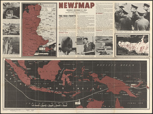
Eastern front [showing German and Soviet attacks]
[Netherlands Indies map showing Japanese-controlled area]
Southwest New Britain
[Globe view with center at Japan showing Japanese-controlled areas of east Asia and the Pacific islands]
- Notes:
-
Relief shown by hachures on New Britain map and shown pictorially on globe view.
"Volume II No. 36."
"Prepared from public sources of information."
"U.S. Government Printing Office: 1943 - 538110."
War fronts: USSR, Southwest Pacific, Italy, Air offensive, Yugoslavia.
Photographs: French troops of 2nd Moroccan Division fight in Italy -- Half-track loaded with Frenchmen crosses the Volturno -- French First Armored Division during maneuvers -- B-25 Mitchell bomber -- 75mm shell for the cannon on the Mitchell bomber -- Japanese destroyer after being hit by shells from the Mitchell bomber -- Gen. Bernard Montgomery commander of the British Eighth Army explains battle strategy to Soviet generals: Maj. Gen. Vasiliev and Maj. Gen. Solodvnik.
Includes "Land of the setting sun" text and 11 map drawings showing the progression of Japan's land acquisitions from 1875 to Nov.1 1942.
Globe view and drawings by Richard Edes Harrison [reprinted from Fortune].
- Notes (exhibitions):
-
Exhibited: "Bending lines: maps and data from distortion to deception," organized by the Norman B. Leventhal Map & Education Center at the Boston Public Library, 2020-2021.
- Identifier:
-
06_01_017125
- Call #:
-
W 109.107:2/36
- Barcode:
-
39999085954012


