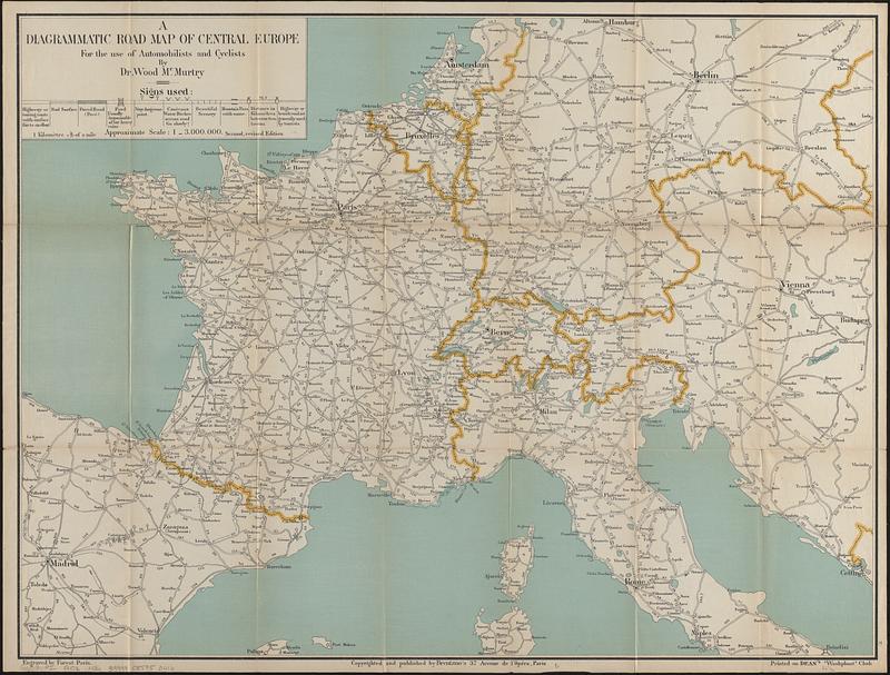
A diagrammatic road map of Central Europe : for the use of automobilists and cyclists
Item Information
- Title:
- A diagrammatic road map of Central Europe : for the use of automobilists and cyclists
- Cartographer:
- McMurtry, Wood
- Name on Item:
-
by Dr. Wood McMurtry ; engraved by Forest
- Date:
-
[1910–1918]
- Format:
-
Maps/Atlases
- Location:
-
Boston Public Library
Norman B. Leventhal Map & Education Center - Collection (local):
-
Norman B. Leventhal Map & Education Center Collection
- Subjects:
-
Europe, Central--Maps
Roads--Europe, Central--Maps
- Places:
-
Central Europe (area)
- Extent:
- 1 map : cloth, color ; 49 x 65 cm, folded in cover 18 x 11 cm
- Terms of Use:
-
No known copyright restrictions.
No known restrictions on use.
- Publisher:
-
Paris :
Brentano's
- Edition:
- Second, revised edition
- Scale:
-
Scale approximately 1:3,000,000
- Language:
-
English
- Notes:
-
Shows types of roads and distances.
Oriented with north towards the upper right.
"Printed on Dean's 'Washphast' cloth."
- Notes (date):
-
This date is inferred.
- Identifier:
-
06_01_016711
- Call #:
-
G6031.P2 1910z .M36
- Barcode:
-
39999085950416