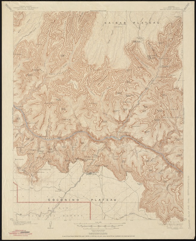
Arizona (Coconino County), Bright Angel quadrangle
Item Information
- Title:
- Arizona (Coconino County), Bright Angel quadrangle
- Title (alt.):
-
Bright Angel quadrangle
Coconino County
Grand Canyon of the Colorado River
- Creator:
- Geological Survey (U.S.)
- Name on Item:
-
U.S. Geological Survey ; E.M. Douglas, geographer in charge ; topography by Franc̜ois E. Matthes.
- Date:
-
[1903]
- Format:
-
Maps/Atlases
- Location:
-
Boston Public Library
Norman B. Leventhal Map & Education Center - Collection (local):
-
Norman B. Leventhal Map & Education Center Collection
- Subjects:
-
Coconino County (Ariz.)--Maps
Arizona--Maps
Grand Canyon (Ariz.)--Maps
- Places:
-
ArizonaCoconino (county)
ArizonaGrand Canyon (area)
- Extent:
- 1 map : col. ; 60 x 47 cm.
- Terms of Use:
-
No known copyright restrictions.
No known restrictions on use.
- Publisher:
-
[Washington] :
The Survey
- Scale:
-
Scale 1:48,000
- Language:
-
English
- Notes:
-
Surveyed in 1902-1903.
"Contour interval 50 feet." Relief also shown by spot heights.
"The Grand Canyon of the Colorado River by Francois E. Matthes"--Verso.
- Notes (date):
-
This date is inferred.
- Identifier:
-
06_01_010394
- Call #:
-
G4333.C6C2 1903 .G46
- Barcode:
-
39999065671636