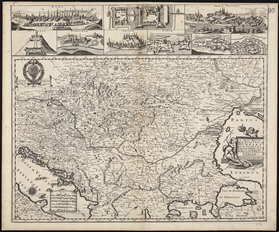
A new mapp of the Kingdom of Hungary and the states that have been subject to it, which are at present the northern parts of Turkey in Europe
Item Information
- Title:
- A new mapp of the Kingdom of Hungary and the states that have been subject to it, which are at present the northern parts of Turkey in Europe
- Title (alt.):
-
Collection of old maps
- Creator:
- Lea, Philip, fl. 1683-1700
- Date:
-
[1695]
- Format:
-
Maps/Atlases
- Location:
-
Boston Public Library
Norman B. Leventhal Map & Education Center - Collection (local):
-
Norman B. Leventhal Map & Education Center Collection
- Subjects:
-
Hungary--Maps--Early works to 1800
Hungary--Administrative and political divisions--Maps--Early works to 1800
Balkan Peninsula--Maps--Early works to 1800
Balkan Peninsula--Administrative and political divisions--Maps--Early works to 1800
1695
- Places:
-
Balkan Peninsula (area)
Hungary
- Extent:
- 1 map : col. ; 37 x 57 cm, on sheet 50 x 56 cm.
- Terms of Use:
-
No known copyright restrictions.
No known restrictions on use.
- Publisher:
-
London :
Printed for Tho: Terrey at ye Red Lyon without Newgate, and Ric. Palmer in Fullwood Rents, near Grayes Inn Stationer
- Scale:
-
Scale [ca. 1:3,500,000]
- Language:
-
English
- Notes:
-
Covers greater Hungary and the northern Balkan Peninsula.
Relief shown pictorially.
"R. Palmer sculp."
Statement of dedication at upper left: To His Royall Highness George, Prince of Denmark and Norway & ca., this mapp is humbly dedicated and presented by Richard Palmer.
Includes pictorial title cartouche, coat-of-arms, and 9 views of fortified towns in Hungary and the northern Balkans.
Cataloging, conservation, and digitization made possible in part by The National Endowment for the Humanities: Exploring the human endeavor.
Part of composite portfolio atlas with title "Collection of old maps."
- Notes (date):
-
This date is inferred.
- Identifier:
-
06_01_009282
- Call #:
-
G1015 .C65 1630
- Barcode:
-
30000003858190

![Regni Hungariae, et regionum, quae ei quondam fuêre unitae, ut Transilvaniae, Valachiae, Moldaviae, Serviae, Romaniae, Bulgariae, Bessarabiae, Croatiae, Bosniae, Dalmatiae, Sclavoniae, Morlachiae, Ragusanae Reipublicae, maximaeq[ue] partis Danubii Fluminis, novissima delineatio](https://bpldcassets.blob.core.windows.net/derivatives/images/commonwealth:cj82ks70z/image_thumbnail_300.jpg)