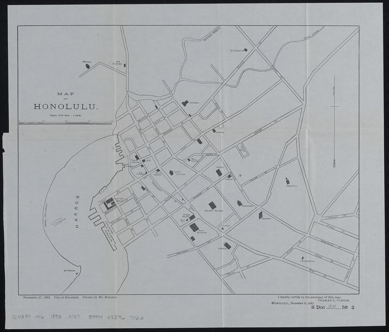
Map of Honolulu
Item Information
- Title:
- Map of Honolulu
- Title (alt.):
-
December 27, 1893, plat of Honolulu
- Description:
-
Map of central Honolulu showing streets, building footprints of selected major buildings, and streams.
- Cartographer:
- Emerson, Oliver P.
- Contributor:
- Carter, Charles L., -1895
- Contributor:
- United States. Congress. Senate. Committee on Foreign Relations
- Contributor:
- United States. Congress (56th, 2nd session : 1900-1901). Senate
- Name on Item:
-
proven by Mr. Emerson ; [certified by] Charles C. Carter
- Date:
-
[1901]
- Format:
-
Maps/Atlases
- Location:
-
Boston Public Library
Norman B. Leventhal Map & Education Center - Collection (local):
-
Norman B. Leventhal Map & Education Center Collection
- Subjects:
-
Honolulu (Hawaii)--Maps
- Places:
-
HawaiiHonolulu (county)Honolulu
- Extent:
- 1 map ; 30 x 38 cm
- Terms of Use:
-
No known copyright restrictions.
No known restrictions on use.
- Publisher:
-
[Washington, D.C.] :
[Government Printing Office]
- Scale:
-
Scale 1:6,000. 500 ft. = 1 in
- Language:
-
English
- Notes:
-
Map detached from a United States Senate document (Serial Set 4052 S.doc.231): Compilation of reports of Committee on Foreign Relations, United States Senate, 1789-1901, first Congress, first session, to fifty-sixth Congress, second session. Vol. VI, Diplomatic relations with foreign nations. Hawaiian Islands. Washington : Government Printing Office, 1901.
"January 15, 1901."--Page 2 of accompanying Senate document.
"December 27, 1893. Plat of Honolulu. Proven by Mr. Emerson."--Lower left margin.
"Sworn statement of Rev. Oliver P. Emerson"--Page 533 of accompanying Senate document.
"I hereby certify to the accuracy of this map. Charles L. Carter."--Lower right margin.
"S Doc 231 56 2"--Lower right margin.
- Notes (date):
-
This date is inferred.
- Identifier:
-
06_01_018397
- Call #:
-
G4384.H6 1893 .M37
- Barcode:
-
39999085967022