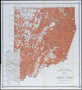
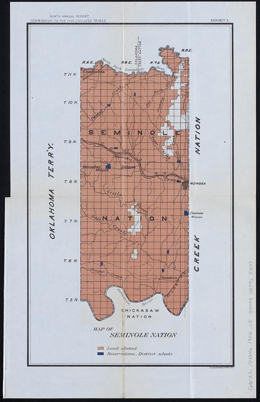
Map of Seminole Nation
Item Information
- Title:
- Map of Seminole Nation
- Description:
-
Map of Seminole Nation, coextensive with land area that would later become Seminole County, Oklahoma, colored to show "land allotments" and "reservations, District schools." Shows Public Land Survey System townships and sections, cities and towns, and water features.
- Cartographer:
- United States. Commission to the Five Civilized Tribes
- Lithographer:
- Julius Bien & Co.
- Date:
-
[1903]
- Format:
-
Maps/Atlases
- Location:
-
Boston Public Library
Norman B. Leventhal Map & Education Center - Collection (local):
-
Norman B. Leventhal Map & Education Center Collection
- Subjects:
-
Seminole Nation of Oklahoma--Maps
Seminole Indians--Land tenure--Seminole Nation of Oklahoma--Maps
Real property--Seminole Nation of Oklahoma--Maps
Schools--Seminole Nation of Oklahoma--Maps
Indian reservations--Oklahoma--Maps
Seminole Indians--Oklahoma--Maps
- Places:
-
Oklahoma
- Extent:
- 1 map : color ; 39 x 23 cm
- Terms of Use:
-
No known copyright restrictions.
No known restrictions on use.
- Publisher:
-
[Washington] :
[Government Printing Office]
- Edition:
- [United States congressional serial set edition]
- Scale:
-
Scale approximately 1:215,000
- Language:
-
English
- Notes:
-
Detached from a United States House of Representatives document in the United States congressional serial set (Serial Set 4459 H.doc.5/4), following page 164: Annual reports of the Department of the Interior for the fiscal year ended June 30, 1902. Indian affairs, part II. Washington : Government Printing Office, 1903.
In top margin: "Ninth annual report, Commission to the five civilized tribes. Exhibit 3."
Shows land allotted and reservations, district schools.
- Notes (date):
-
This date is inferred.
- Identifier:
-
06_01_018345
- Call #:
-
G4022.S4G46 1902 .U5
- Barcode:
-
39999085965307