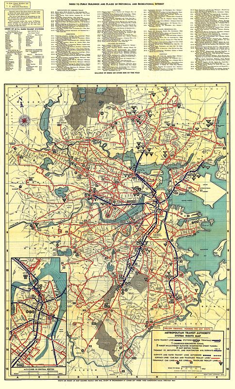
Metropolitan Transit Authority system route map

Item Information
- Title:
- Metropolitan Transit Authority system route map
- Title (alt.):
-
System route map
- Cartographer:
- Lufkin, Richard F. (Richard Friend)
- Publisher:
- Metropolitan Transit Authority (Boston, Mass.)
- Printer:
- Buck Printing Co.
- Name on Item:
-
Richard F. Lufkin, cartographer
- Date:
-
[1952]
- Format:
-
Maps/Atlases
- Location:
-
Boston Public Library
Norman B. Leventhal Map & Education Center - Collection (local):
-
Norman B. Leventhal Map & Education Center Collection
- Subjects:
-
Local transit--Massachusetts--Boston--Maps
Boston (Mass.)--Maps
Metropolitan Transit Authority (Boston, Mass.)
- Places:
-
MassachusettsSuffolk (county)Boston
- Extent:
- 1 map : color
- Terms of Use:
-
No known copyright restrictions.
No known restrictions on use.
- Publisher:
-
Boston :
Metropolitan Transit Authority
- Edition:
- Third M.T.A. edition
- Language:
-
English
- Notes:
-
Oriented with north to the upper left.
Inset: M.T.A. lines in central Boston.
Includes indexes to transit stations and places of interest.
Text, schedules and continuation of index to places of interest on verso.
- Notes (date):
-
This date is inferred.
- Identifier:
-
1952-System-Map
1952-System-Cover
- Call #:
-
G3764.B6P33 svar .B67
- Barcode:
-
39999065669267


