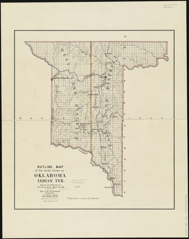
Outline map of the lands known as Oklahoma, Indian Ter. opened to settlement by Executive Order March 23, 1889
Item Information
- Title:
- Outline map of the lands known as Oklahoma, Indian Ter. opened to settlement by Executive Order March 23, 1889
- Description:
-
America Transformed: The Indian Removal Act of 1830 allocated the eastern portion of today's Oklahoma for the Chahta (Choctaw), Chikasha (Chickasaw), Mvskoke (Creek), Semvnole (Seminole), and Tsalagi (Cherokee) and other eastern tribal nations. Following the Civil War, the U.S. government assigned much of western Oklahoma to tribes living on the Great Plains and further west. When President Benjamin Harrison took office in 1889, he signed a proclamation opening 1.9 million acres of "Indian territory" to non-Natives for homesteading. This map depicts the territory made available for settlement on April 22, 1889. That day, over 50,000 people raced to claim the best lands, including lots in the emerging towns of Guthrie and Oklahoma City.
- Creator:
- United States. General Land Office
- Name on Item:
-
Hon. S. M. Stockslager, commissioner; G. U. Mayo, Civ Engr., Chief of Drafting Division [G.L.O.].
- Date:
-
1889
- Format:
-
Maps/Atlases
- Location:
-
Boston Public Library
Norman B. Leventhal Map & Education Center - Collection (local):
-
Norman B. Leventhal Map & Education Center Collection
- Subjects:
-
Oklahoma--Maps
Indian Territory--Maps
- Places:
-
Oklahoma
- Extent:
- 1 map : col. ; 61 x 54 cm.
- Terms of Use:
-
No known copyright restrictions.
No known restrictions on use.
- Publisher:
-
Washington? :
[General Land Office]
- Scale:
-
Scale [1:253,400]. 4 miles to 1 inch
- Language:
-
English
- Notes:
-
Prime meridian: Washington.
- Notes (exhibitions):
-
Exhibited: "America Transformed. Part 2: Homesteads to Modern Cities," organized by the Norman B. Leventhal Map & Education Center at the Boston Public Library, 2019-2020.
- Identifier:
-
06_01_008862
- Call #:
-
G4020 1889 .U55
- Barcode:
-
39999065657528


